Resources for
Innovative
Resource
Level of Effort:
NYSDEC Living Shoreline Map
Check out our interactive map to learn about living shoreline projects located in the marine district of New York.
More information about living shorelines and their benefits can be found on the NYSDEC Living Shorelines webpage.
Resource
Level of Effort:
NYSDEC Living Shoreline Map
Check out our interactive map to learn about living shoreline projects located in the marine district of New York.
More information about living shorelines and their benefits can be found on the NYSDEC Living Shorelines webpage.
SRC Training
4th Annual SRC Workshop: Session 2 – Using Nature-Based Solutions for Resilience
The Long Island Sound Sustainable and Resilient Communities (SRC) Team held our 2025 Annual Workshop virtually as three sessions over two days. Session topics focused on resources and tools available to help take advantage of state resilience funds, a panel discussion on why and how to incorporate nature-based solutions into resilience planning, and an overview of our available assistance programs.
Session 2 – Using Nature-Based Solutions for Resilience: A Panel Discussion on Common Challenges & Strategies for Success was held on Thursday, December 4, 2025. In this interactive session, practitioners and experts discussed techniques for integrating nature-based solutions into resilience initiatives. The panel highlighted common challenges and shared successful strategies from projects in the Long Island Sound region. Video of the session along with supporting materials is available below.
Website
Level of Effort:
The Atlas of Inspiration
The Atlas of Inspiration is a national database that highlights real projects helping communities adapt to extreme weather, flooding, heat, and sea-level rise. It showcases innovative infrastructure, planning strategies, and funding approaches that can be adapted or scaled by other communities. The Atlas is designed to celebrate successful ideas and give decision-makers examples they can use when seeking state or federal funding.
The Atlas is fully searchable, allowing users to browse projects by type, climate hazard, or location. It builds on Rebuild by Design’s earlier work including the Atlas of Disaster and the Atlas of Accountability by showing not only the risks communities face, but the solutions that are already making a difference.
Rebuild by Design also invites communities to share their own climate resilience projects for inclusion in the Atlas. Submissions help expand the collection and highlight new approaches being used across the country.
Website
Level of Effort:
GSI Impact Hub
The GSI Impact Hub is an interactive platform that provides tools, research, and data to help communities plan and evaluate green stormwater infrastructure (GSI) projects. GSI uses natural systems like plants, soil, and stone to manage stormwater on-site reducing flooding, improving water quality, and creating healthier, more resilient neighborhoods. The Hub includes a benefits calculator, educational resources, and guidance to support city planners, advocates, and policymakers in designing projects that maximize environmental, social, and economic benefits.
Explore the GSI Impact Calculator, Detailed Resource Library, and Project Background to better understand how GSI can reduce flooding, improve water quality, and build climate-resilient neighborhoods.
Resource
Level of Effort:
How vegetated buffers protect water quality, and a whole lot more
Use this fact sheet to learn about riparian buffers and how they can be a tool for filtering excess nutrients and sediment from runoff, reducing flood impacts, and providing habitat. Learn more about buffers using this fact sheet. Details include what buffers are, why they are important, best practice recommendations, and design considerations.
SRC Training
This field trip was part of a Community Resilience Project Showcase leading up to the 2024 Annual SRC Workshop.
Hamden Bioretention Project Tour & Workshop
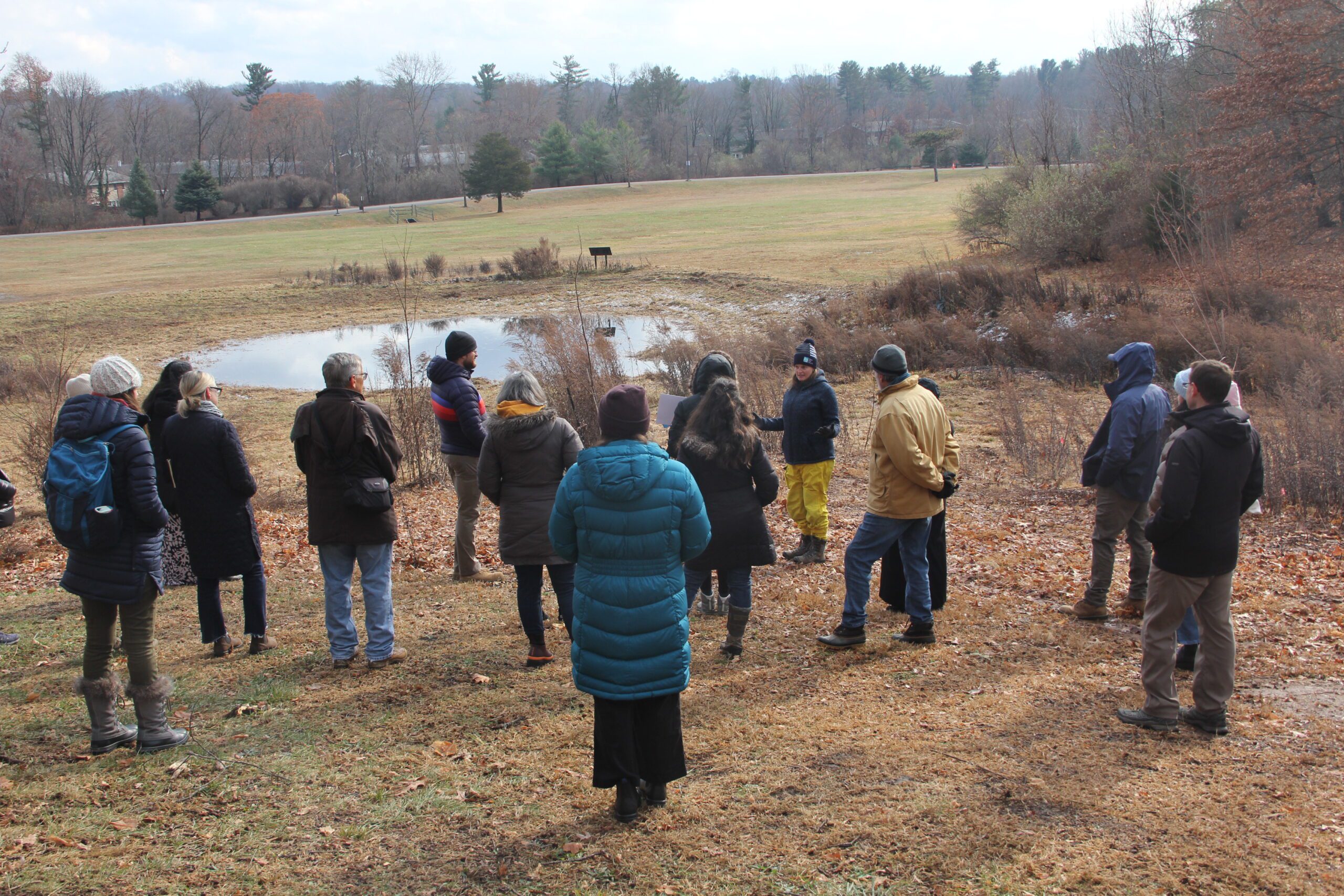 On December 5, 2024, the Sustainable and Resilient Communities (SRC) team of the Long Island Sound Study hosted a field trip featuring the Town of Hamden’s Bioretention Project – the largest municipally owned rain garden in the state! Participants began with a guided tour of the rain garden and bioretention areas at Town Center Park, where they heard from project planners and managers about its history, partnerships, challenges, and maintenance. Following this, participants gathered at the Hamden Government Center for a working lunch and presentations on topics including UConn’s Stormwater Corps, native plants, project engineering, and using nature-based solutions to advance climate resilience goals. The day concluded with a lively group discussion. Special thanks to our partners with the Town of Hamden, Save the Sound, the Hamden Land Trust, and UConn Extension.
Photo credit: Judy Benson
SRC Training
This field trip was part of a Community Resilience Project Showcase leading up to the 2024 Annual SRC Workshop.
Hamden Bioretention Project Tour & Workshop
On December 5, 2024, the Sustainable and Resilient Communities (SRC) team of the Long Island Sound Study hosted a field trip featuring the Town of Hamden’s Bioretention Project – the largest municipally owned rain garden in the state! Participants began with a guided tour of the rain garden and bioretention areas at Town Center Park, where they heard from project planners and managers about its history, partnerships, challenges, and maintenance. Following this, participants gathered at the Hamden Government Center for a working lunch and presentations on topics including UConn’s Stormwater Corps, native plants, project engineering, and using nature-based solutions to advance climate resilience goals. The day concluded with a lively group discussion. Special thanks to our partners with the Town of Hamden, Save the Sound, the Hamden Land Trust, and UConn Extension.
Photo credit: Judy Benson
SRC Training
3rd Annual SRC Workshop: Session 3 – Planning for Inundation
The Long Island Sound Sustainable and Resilient Communities (SRC) Team held our 2024 Annual Workshop virtually as three sessions over two days. Session topics focused on our assistance programs, new regional resilience resources and tools, and a discussion on planning for inundation and different considerations communities may face.
Session 3 – Planning for Inundation was held on Wednesday, December 11th from 10 AM-12 PM. Participants heard from communities and regional entities that are using or considering different aspects of planning for inundation, including buyout programs, land use policies, and community perspectives on retreat/relocation.
Case Study
Project
Sunken Meadow State Park Restoration
Increased development and the historic construction of a dam on Sunken Meadow Creek in the 1950’s led to reduced tidal exchange, increased water levels in the creek, poor water quality, and the proliferation of invasive species. In 2008 a number of partners (NYS OPRHP, NOAA, NYSDEC, LISS, TNC, Save the Sound, USFWS, LI Botanical Society) came together to work to restore the degraded marsh habitat around Sunken Meadow Creek, increase tidal flow, improve aquatic organism passage, limit invasives, and improve water quality. A restoration feasibility study was completed in 2010. In 2012 Superstorm Sandy blew out the dam on Sunken Meadow Creek, naturally kick-starting restoration. Following Superstorm Sandy, the project partners were able to quickly capitalize on available funding and grants, due to their prior planning efforts. A bridge was built across the Creek where the dam blew out, salt marsh habitat was restored at three locations, green infrastructure was installed in one of the parking areas to capture and treat stormwater runoff, fish passage feasibility on the creek was investigated, and education and outreach was conducted to thousands of people. These projects were completed in 2019. Now, with funding through Long Island Sound Futures Fund, Audubon NY is leading a large-scale marsh restoration project at Sunken Meadow Creek to restore important high-marsh habitat for at risk species, like the Saltmarsh Sparrow, and to increase the resilience of the marsh in the face of rising sea levels. Audubon will be working to finalize the designs and secure permits over the next two years, with on-the-ground restoration expected in 2026.


Overall the project has been highly successful, reducing flooding, polluted runoff, and invasives, as well as increasing the recreational value and beauty of the Park. There has been positive feedback from the public following the restoration projects. Some challenges remain with dealing with invasive species. It was determined that proceeding with the fish passage plans was not worthwhile, following the feasibility assessment.
Sean Cruickshank Sean.Cruickshank@parks.ny.gov, Jon Vander Werff jvanderwerff@savethesound.org, Phoebe Clark phoebe.clark@audubon.org, Vicky O’Neill victoria.oneill@audubon.org
Case Study
Project
Sunken Meadow State Park Restoration
Increased development and the historic construction of a dam on Sunken Meadow Creek in the 1950’s led to reduced tidal exchange, increased water levels in the creek, poor water quality, and the proliferation of invasive species. In 2008 a number of partners (NYS OPRHP, NOAA, NYSDEC, LISS, TNC, Save the Sound, USFWS, LI Botanical Society) came together to work to restore the degraded marsh habitat around Sunken Meadow Creek, increase tidal flow, improve aquatic organism passage, limit invasives, and improve water quality. A restoration feasibility study was completed in 2010. In 2012 Superstorm Sandy blew out the dam on Sunken Meadow Creek, naturally kick-starting restoration. Following Superstorm Sandy, the project partners were able to quickly capitalize on available funding and grants, due to their prior planning efforts. A bridge was built across the Creek where the dam blew out, salt marsh habitat was restored at three locations, green infrastructure was installed in one of the parking areas to capture and treat stormwater runoff, fish passage feasibility on the creek was investigated, and education and outreach was conducted to thousands of people. These projects were completed in 2019. Now, with funding through Long Island Sound Futures Fund, Audubon NY is leading a large-scale marsh restoration project at Sunken Meadow Creek to restore important high-marsh habitat for at risk species, like the Saltmarsh Sparrow, and to increase the resilience of the marsh in the face of rising sea levels. Audubon will be working to finalize the designs and secure permits over the next two years, with on-the-ground restoration expected in 2026.
Case Study
Project
Maidstone Landing Bluff Restoration
The Maidstone Landing Association, situated between Town of Riverhead Iron Pier Beach and Hallock State Park, wanted to take action to mitigate erosion of their bluff. First they worked with Town of Riverhead to put up signage and fencing to stop beachgoers from climbing and driving on or near the bluff, which was causing significant destruction. Next they opted for a small-scale, nature-based approach to help stabilize the bluff. They purchased snow fencing from Home Depot and native beachgrass from Long Island Natives. They engaged Riverhead Charter High School to help with putting up the snow fencing and the plantings. The Maidstone Landing Association is using their bluff as an “outdoor classroom” to teach students and the public about the importance of conserving our coastal habitats and best practices.


The beachgrass is now thriving, and the both the fencing and plants have held up during recent storms. Maidstone Landing Association recently received approval to expand the project across their entire bluff. The Association plans to continue to collaborate with New York Sea Grant, Long Island Sound Study, and Suffolk Soil & Water Conservation District, to use this project to educate students and the public on best practices and the importance of protecting our coastal bluffs.
Tom Mohrman mustangtpm@gmail.com; Corey Humphrey corey.humphrey@suffolkcountyny.gov
Case Study
Project
Maidstone Landing Bluff Restoration
The Maidstone Landing Association, situated between Town of Riverhead Iron Pier Beach and Hallock State Park, wanted to take action to mitigate erosion of their bluff. First they worked with Town of Riverhead to put up signage and fencing to stop beachgoers from climbing and driving on or near the bluff, which was causing significant destruction. Next they opted for a small-scale, nature-based approach to help stabilize the bluff. They purchased snow fencing from Home Depot and native beachgrass from Long Island Natives. They engaged Riverhead Charter High School to help with putting up the snow fencing and the plantings. The Maidstone Landing Association is using their bluff as an “outdoor classroom” to teach students and the public about the importance of conserving our coastal habitats and best practices.
Case Study
Project
Stratford, CT
Restoration of the Great Meadows Marsh
This project restored 46 acres of the Great Meadows Marsh in Connecticut that was degraded from dredge material that was dumped on site, poor drainage, and sea level rise. The marsh was also overrun with invasive plants and mosquitoes. A controlled fire was started to kill the invasive reeds growing in the marsh. Then a construction crew removed invasive plants and the dumped dredge material. Lastly, channels were carefully dug for tidal flushing which will allow the marsh to keep pace with sea level rise. Soil hummocks were constructed for Salt Marsh Sparrow habitat. Now the area continues to be monitored, assessed for resiliency, and provides a field for innovative solutions to be tested in.
Partners
Trustees: USFWS, NOAA, State of Connecticut; Project Partners: Audubon Connecticut, Town of Stratford
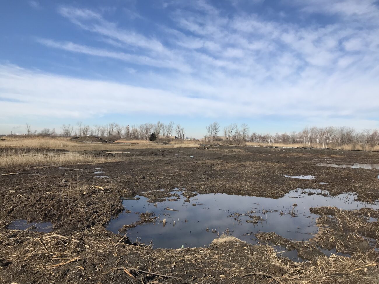


Monitoring immediately following the restoration revealed at least 12 saltmarsh sparrows returned to their annual nesting areas near the experimental hummocks, despite the disruptive activities taking place earlier in the year. University students will survey vegetation on the hummocks and throughout the restoration area, measuring and counting individual plants to see how different species grow at different elevations and in different types of soil, and to determine if additional plantings are needed. Audubon Connecticut will manage and control invasive plant species across the restoration area for three years, periodically removing and chemically treating the ever-persistent common reed. The project team will also monitor saltwater flooding of the marsh and carve runnels (short channels), if needed, to connect more areas to saltwater.
Molly Sperduto at molly_sperduto@fws.gov;
Corrie Folsom-O’Keefe cfolsom.okeefe@audubon.org;
Jack Matthias jack.matthias@audubon.org
Case Study
Project
Stratford, CT
Restoration of the Great Meadows Marsh
This project restored 46 acres of the Great Meadows Marsh in Connecticut that was degraded from dredge material that was dumped on site, poor drainage, and sea level rise. The marsh was also overrun with invasive plants and mosquitoes. A controlled fire was started to kill the invasive reeds growing in the marsh. Then a construction crew removed invasive plants and the dumped dredge material. Lastly, channels were carefully dug for tidal flushing which will allow the marsh to keep pace with sea level rise. Soil hummocks were constructed for Salt Marsh Sparrow habitat. Now the area continues to be monitored, assessed for resiliency, and provides a field for innovative solutions to be tested in.
Partners
Trustees: USFWS, NOAA, State of Connecticut; Project Partners: Audubon Connecticut, Town of Stratford
Case Study
Project
New Haven, CT
New Haven Bioswales
The City of New Haven has installed 286 right-of-way bioswales throughout the city as part of a multifaceted approach to reducing flooding in the downtown area. Right-of-way bioswales are engineered planted areas that are located on sidewalks. They are designed to capture and infiltrate stormwater into the ground that would otherwise directly enter a storm drain. These bioswales were installed as the result of various partnerships and funding opportunities related to flood prevention, localized drainage solutions, combined sewer overflow mitigation, research, and traffic calming projects.
Project Lead
City of New Haven, Dept of Engineering
Project Partners
Urban Resources Initiative, EMERGE Inc., Save the Sound, Yale School of the Environment, and Quinnipiac University, among others.

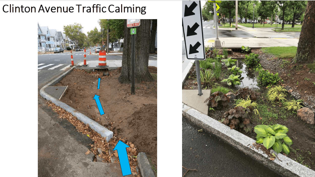

Monitoring performed by Yale School of the Environment researchers (led by Prof. Gaboury Benoit) have demonstrated that the bioswales have captured 70-75% of stormwater runoff in two locations. These results indicate that the bioswales are highly effective in diverting stormwater and thus, preventing pollution.
Dawn Henning
dhenning@newhavenct.gov
475-434-1643
Case Study
Project
New Haven, CT
New Haven Bioswales
The City of New Haven has installed 286 right-of-way bioswales throughout the city as part of a multifaceted approach to reducing flooding in the downtown area. Right-of-way bioswales are engineered planted areas that are located on sidewalks. They are designed to capture and infiltrate stormwater into the ground that would otherwise directly enter a storm drain. These bioswales were installed as the result of various partnerships and funding opportunities related to flood prevention, localized drainage solutions, combined sewer overflow mitigation, research, and traffic calming projects.
Project Lead
City of New Haven, Dept of Engineering
Project Partners
Urban Resources Initiative, EMERGE Inc., Save the Sound, Yale School of the Environment, and Quinnipiac University, among others.
Guidance Tool
Level of Effort:
Promoting Nature-Based Hazard Mitigation Through FEMA Mitigation Grants
This guidance document is intended for stakeholders pursuing FEMA HMA grants for nature-based solutions to mitigate risks associated with flooding (riverine and coastal) and wildfire.
Guidance Tool
Level of Effort:
Promoting Nature-Based Hazard Mitigation Through FEMA Mitigation Grants
This guidance document is intended for stakeholders pursuing FEMA HMA grants for nature-based solutions to mitigate risks associated with flooding (riverine and coastal) and wildfire.
Mapper
Level of Effort:
Long Island Water Reuse Road Map and Action Plan
Seatuck and the Greentree Foundation, in association with Cameron Engineering, initiated the Long Island Water Reuse Roadmap and Action Plan to catalyze the implementation of water reuse on Long Island and ensure that the strategy plays a larger and more meaningful role in safeguarding the region’s drinking water and surface water resources.
Website
Level of Effort:
Understanding Living Shorelines
NOAA overview of living shorelines and their benefits, steps to construction. There is a good map of places where they have been constructed around the US. It is a good place to get basic info about living shorelines, with appropriate links to more specific information like how to get a permit
Guidance Tool
Level of Effort:
CT DEEP Living Shorelines
CT state resource on living shorelines, with a few good fact sheets and pages about types of living shoreline techniques and permitting for our state. There is also a list of pilot projects in CT.
Guidance Tool
Level of Effort:
CT DEEP Living Shorelines
CT state resource on living shorelines, with a few good fact sheets and pages about types of living shoreline techniques and permitting for our state. There is also a list of pilot projects in CT.
Guidance Tool
Level of Effort:
NYSDEC/NYSDOS Using Natural Measures to Reduce the Risk of Flooding and Erosion
This document developed in support of the NYS Community Risk and Resiliency Act 1) Describes natural resilience measures and how they can be used to mitigate the risks of flooding and erosion, 2) Provides definitions for different types of natural resilience measures and distinguishes among conserved, restored, nature-based and hard structural approaches, 3) Provides information on the value and benefits of using natural resilience measures, along with information on the co-benefits they provide, 4) Lists key factors to consider in the restoration, design and construction of natural resilience measures, and 5) Provides background to support the development of NYS agency guidance on natural resilience measures in the future
Guidance Tool
Level of Effort:
Building Community Resilience with Nature-Based Solutions: A Guide for Local Communities (FEMA)
The primary goal of this guide is to help communities identify and engage the staff and resources that can be used to implement nature-based solutions to build resilience to natural hazards, which may be exacerbated by climate change.
Story Map
Level of Effort:
NY Sea Grant Long Island Dynamic Shorelines
This story map examines the coastal processes and hazards of Long Island and provides options for sustainable and resilient shoreline management. Information is useful for coastal managers, planners and coastal property owners.
Story Map
Level of Effort:
NY Sea Grant Long Island Dynamic Shorelines
This story map examines the coastal processes and hazards of Long Island and provides options for sustainable and resilient shoreline management. Information is useful for coastal managers, planners and coastal property owners.
Website
Level of Effort:
Living Shorelines Academy
Learn about living shorelines and their benefits to communities. This website contains training modules, a white papers database, a database of living shoreline projects, professionals directory, and online forum.
Website
Level of Effort:
Living Shorelines Academy
Learn about living shorelines and their benefits to communities. This website contains training modules, a white papers database, a database of living shoreline projects, professionals directory, and online forum.
Guidance Tool
Level of Effort:
Georgetown Climate Center Managed Retreat Toolkit
This toolkit features legal and policy tools, best and emerging practices, and case studies to support learning and decision making around managed retreat and climate adaptation. It is meant to be used by state, territorial, and local policymakers in U.S. coastal jurisdictions
Guidance Tool
Level of Effort:
Building Community Resilience with Nature-Based Solutions: Strategies for Success (FEMA)
This guide gives community leaders five main strategies to carry out Nature-Based Solution projects: 1) Building Strong Partnerships, 2) Engaging the Whole Community, 3) Matching Project Size with Desired Goals and Benefits, 4) Maximizing Benefits, and 5) Designing for the Future. This is not a technical guide for planning, constructing, or funding NBS. It covers the value of each strategy and suggests how to move forward with NBS projects.
Guidance Tool
Level of Effort:
EPA Green Infrastructure
Includes information about preparing for, and implementing green infrastructure with helpful links to other fact sheets and resources.
Guidance Tool
Level of Effort:
EPA Green Infrastructure
Includes information about preparing for, and implementing green infrastructure with helpful links to other fact sheets and resources.
Training
Living Shorelines
In this Coastal Resiliency Network webinar Suzette Lopane with Westchester County and Marian Russo with the Village of Patchogue spoke about two exciting living shoreline projects. The Coastal Resilience Network, led by the New York State Association of Conservation Commissions (NYSACC) with assistance from NY Sea Grant, is a collaborative open forum for communities in coastal Westchester, Nassau, and Suffolk Counties to discuss and learn about opportunities to increase their resilience to sea level rise, flooding, and extreme events.