Resources for
rain
Mapper
Level of Effort:
NYC Stormwater Flood Maps
The NYC Stormwater Flood Maps show areas in New York City that are at risk of flooding during heavy rain. The tool provides interactive maps that let users explore neighborhood-level flood risk and understand how stormwater might affect streets, homes, and critical infrastructure. It helps residents, planners, and local organizations identify vulnerable areas and make decisions about preparedness, emergency planning, and long-term resilience.
These maps also bring together important environmental and social data, making it easier to compare neighborhoods, see patterns, and understand which communities may face the greatest challenges during extreme weather.
Mapper
Level of Effort:
NOAA Atlas 14: Precipitation Frequency Estimates
Developed by the NOAA National Weather Service Office of Water Prediction, NOAA Atlas 14 provides estimates of expected precipitation depth or intensity in a selected location, given a storm event’s duration and recurrence interval. NOAA Atlas 15 is currently under development and will refine the current dataset and expand upon by providing future projections (this version likely won’t be ready for use in our area until at least 2026, but stay tuned for updates!).
Case Study
Project
Hamden, CT
Town of Hamden’s Bioretention Project
The Town of Hamden’s Bioretention Project is the largest municipally owned rain garden in the state! Save the Sound, in partnership with the Town of Hamden, completed this large-scale rain garden project at Hamden Town Center Park to improve local water quality, restore habitat, and enhance community resilience. The project transformed approximately 2.5 acres of lawn into a functioning green infrastructure system that now manages runoff from an 88-acre urban watershed draining Dixwell Avenue and surrounding neighborhoods. Prior to the project, stormwater often overflowed directly into Pardee Brook and the Mill River, carrying pollutants and inundating the park.
The newly constructed rain garden was engineered with layers of soil, sand, and rock, and planted with more than 7,000 native grasses, flowers, and shrubs thanks to additional support from the Land Trust of Hamden. These plantings naturally filter pollutants such as fertilizers, road salt, and chemicals. Community volunteers helped complete the planting, strengthening local stewardship in the Town of Hamden.


A 40,000 sq ft rain garden was installed and included restoration of an acre of park land. The system now treats over 20 million gallons of stormwater annually, reducing flooding and restoring more natural hydrology to Shepard Brook and the Mill River. Beyond its environmental benefits, the project created valuable wildlife habitat and a welcoming green space for residents to enjoy. Adaptive management, more planting, and stewardship is planned for 2025 and 2026.
Nicole Davis, Save the Sound
Jim Sirch, Hamden Land Conservation Trust
Stephen White, PE, Town of Hamden Engineer/LTA
Case Study
Project
Hamden, CT
Town of Hamden’s Bioretention Project
The Town of Hamden’s Bioretention Project is the largest municipally owned rain garden in the state! Save the Sound, in partnership with the Town of Hamden, completed this large-scale rain garden project at Hamden Town Center Park to improve local water quality, restore habitat, and enhance community resilience. The project transformed approximately 2.5 acres of lawn into a functioning green infrastructure system that now manages runoff from an 88-acre urban watershed draining Dixwell Avenue and surrounding neighborhoods. Prior to the project, stormwater often overflowed directly into Pardee Brook and the Mill River, carrying pollutants and inundating the park.
The newly constructed rain garden was engineered with layers of soil, sand, and rock, and planted with more than 7,000 native grasses, flowers, and shrubs thanks to additional support from the Land Trust of Hamden. These plantings naturally filter pollutants such as fertilizers, road salt, and chemicals. Community volunteers helped complete the planting, strengthening local stewardship in the Town of Hamden.
Resource
Level of Effort:
Sound Ideas for Clean Water
Municipalities are encouraged to use the Sound Ideas for Clean Water brochure in their outreach efforts. The website and brochure outline steps that residents can take to reduce stormwater runoff that can cause pollution and flooding. For more information about this campaign, contact the outreach coordinator for your area (listed here).
Report
Level of Effort:
The Fifth National Climate Assessment
The Fifth National Climate Assessment is the US Government’s preeminent report on climate change impacts, risks, and responses. It is a congressionally mandated interagency effort that provides the scientific foundation to support informed decision-making across the United States.
Case Study
Project
Norwalk, CT
Webster Street Parking Lot Green Infrastructure Project
In 2019, the City of Norwalk secured a LIS Future Fund grant to install green infrastructure in the Webster Street Parking to reduce the impacts of stormwater on the Norwalk River and Harbor and mitigate local flooding of surrounding businesses through the installation of four different types of infiltration and bio-retention structures:
1) Underground infiltration systems.
2) Retention basins and curb inlet planters in eight different areas.
3) Porous pavement with storage in two areas.
4) Infiltration gutters and tree filters in two other areas.
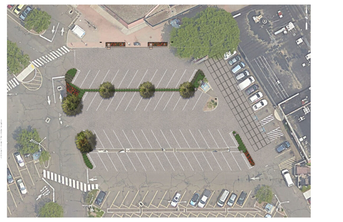

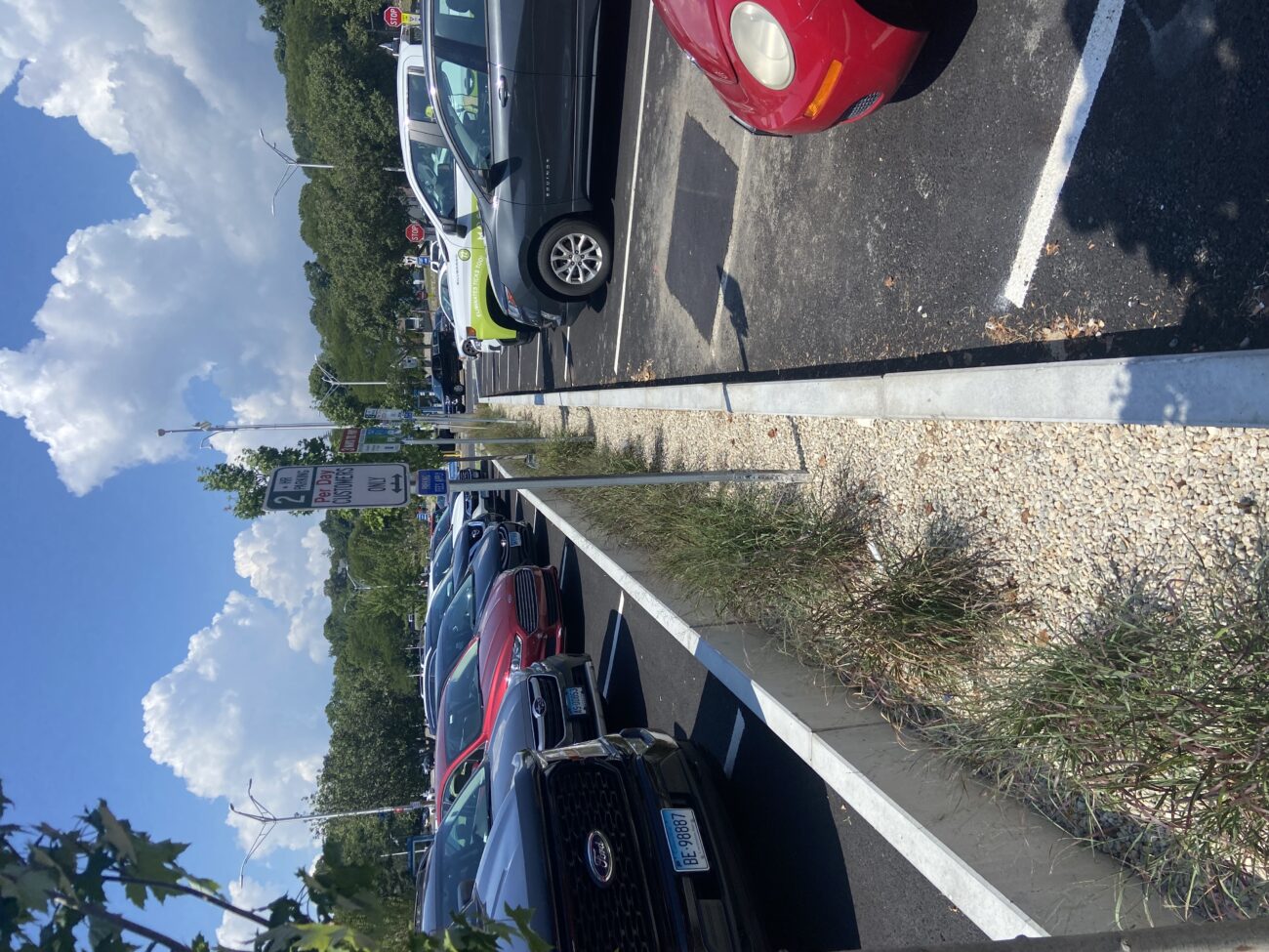


The project is estimated to remove 12 lbs. of nitrogen and preventing over 6 million gallons of stormwater from entering Norwalk Harbor annually. Since it's installation, the site has not experienced any flooding incidents (as of 2024), indicating that it seems to be functioning well.
Bryan Lutz
Assistant Director of Parking
blutz@norwalkct.gov; 203-854-7253
Case Study
Project
Norwalk, CT
Webster Street Parking Lot Green Infrastructure Project
In 2019, the City of Norwalk secured a LIS Future Fund grant to install green infrastructure in the Webster Street Parking to reduce the impacts of stormwater on the Norwalk River and Harbor and mitigate local flooding of surrounding businesses through the installation of four different types of infiltration and bio-retention structures:
1) Underground infiltration systems.
2) Retention basins and curb inlet planters in eight different areas.
3) Porous pavement with storage in two areas.
4) Infiltration gutters and tree filters in two other areas.