Funding
: Mar 27 – May 6, 2025
$100,000 - $10M
The National Coastal Resilience Fund (NCRF) is a national program focused on reducing risks to coastal communities. The NCRF is now soliciting pre-proposals for projects that will create and/or restore natural systems in order to increase protection for communities from coastal hazards, such as storms, sea- and lake-level changes, inundation, and coastal erosion, while improving habitats for fish and wildlife species.
Funding
: Jul 18 – Mar 31, 2025
$10,000-$50,000
This grant opportunity is open to municipalities and non-governmental organizations interested in partnering with SCSWCD to implement a variety of projects focused on improving Suffolk County and its environment. These projects focus on revitalizing and protecting Long Islands ecosystems, waterbodies, ground water and habitats. The goal of this grant is to attract new partners to develop and implement innovative and sustainable solutions for environmental issues.
Report
This factsheet summarizes the findings of a 2022 informal needs assessment of coastal Long Island Sound communities conducted by the Long Island Sound Study’s Sustainable & Resilient Communities (SRC) Working Group Extension Professionals Team. The goal of the needs assessment was to guide future SRC work and to understand: 1) which environmental threats communities are most concerned about, 2) what communities are already doing to address these threats (including their goals and priority projects), 3) what barriers are preventing actions, and 4) what support is needed to overcome those barriers.
Min $100K for Planning Grants, $500K for Implementation
Established through the Bipartisan Infrastructure Law, the Promoting Resilient Operations for Transformative, Efficient, and Cost-Saving Transportation (PROTECT) Discretionary Grant Program aims to help make surface transportation more resilient to natural hazards, including climate change, sea level rise, flooding, extreme weather events, and other natural disasters. Funding is available for planning activities, resilience improvements, community resilience and evacuation routes, and at-risk costal infrastructure. Projects selected under this program should be grounded in the best available scientific understanding of climate change risks, impacts, and vulnerabilities, and should utilize innovative and collaborative approaches to risk reduction, including the use of nature-based solutions.
Mapper
Level of Effort:
This site provides federally supported data visualizations coupled with explanations and science education to help communities prepare for challenges that will affect our coastal environments. By showing how sea levels are changing regionally, the site provides a foundation to inform decision-making related to coastal planning, resource management, and emergency operations.
This website is a collaborative effort from The Interagency Task Force on Sea Level Change (DOD, EPA, FEMA, NASA, NOAA, USACE, USAID, and USGS).
Report
Level of Effort:
The Fifth National Climate Assessment is the US Government’s preeminent report on climate change impacts, risks, and responses. It is a congressionally mandated interagency effort that provides the scientific foundation to support informed decision-making across the United States.
The New York Community Trust, which brings together the New York Community Trust, The Long Island Community Foundation, and Westchester Community Foundation offers competitive grants to nonprofits to support projects in a number of areas across New York City, Westchester, Long Island and beyond. For work on Westchester, proposals are accepted from nonprofits during the specified timeframes.
The New York Community Trust, which brings together the New York Community Trust, The Long Island Community Foundation, and Westchester Community Foundation offers competitive grants to nonprofits to support projects in a number of areas across New York City, Westchester, Long Island and beyond. For work on Westchester, proposals are accepted from nonprofits during the specified timeframes.
The New York Community Trust, which brings together the New York Community Trust, The Long Island Community Foundation, and Westchester Community Foundation offers competitive grants to nonprofits to support projects in a number of areas across New York City, Westchester, Long Island and beyond. For work on Long Island, proposals are accepted from nonprofits during the specified timeframes.
The New York Community Trust, which brings together the New York Community Trust, The Long Island Community Foundation, and Westchester Community Foundation offers competitive grants to nonprofits to support projects in a number of areas across New York City, Westchester, Long Island and beyond. For work on Long Island, proposals are accepted from nonprofits during the specified timeframes.
Website
Level of Effort:
The New York State Climate Impacts Assessment explores current and future climate change impacts to New York State communities, ecosystems, and economy. The New York State Energy Research and Development Authority (NYSERDA) assembled more than 250 New York–based, national, and Indigenous climate science experts and representatives from diverse communities and industries across the state to contribute to this assessment. The findings are intended to help residents, businesses, and decision-makers across the state plan and prepare for climate change impacts.
Funding
: Jul 18, 2025
$500 - $1,000
Awards small grants in support of grassroots efforts and community-based environmental work in New England. The Grassroots Fund utilizes participatory grantmaking to move resources to New England grassroots groups working at the intersections of Environmental Justice. The program is geared toward groups who have some experience implementing a project in their community. Grants support groups to deepen their work by further developing a community vision, lowering barriers to participation, identifying new stakeholders, and working to bring more voices and lived experiences into core decision-making processes.
Funding
: Feb 22 – Apr 10, 2024
$100,000 - $10M
The NCRF is a national program with the goal of enhancing protection for coastal communities from the impacts of storms, floods, and other natural coastal hazards and to improve habitats for fish and wildlife. This year, NFWF will award approximately $140 million in grants for the planning, design, and implementation of natural and nature-based solutions.
Funding
: Oct 12 – Dec 15, 2023
$800M total available
The Flood Mitigation Assistance grant program is a competitive program that provides funding to states, federally recognized Tribal governments, U.S. territories, and local governments. Since the National Flood Insurance Reform Act of 1994 was signed into law, funds are used for projects that reduce or eliminate the risk of repetitive flood damage to buildings insured by the National Flood Insurance Program.
Funding
: Oct 12 – Dec 15, 2023
$1B total available
The Federal Emergency Management Agency (FEMA) Building Resilient Infrastructure and Communities (BRIC) grant program will support states, local communities, tribes and territories as they undertake hazard mitigation projects, reducing the risks they face from disasters and natural hazards. The BRIC program’s guiding principles are to support communities through capability and capacity building, encourage and enable innovation; promote partnerships, enable large projects, maintain flexibility, and provide consistency.
up to $50,000
The Nature Conservancy is pleased to announce a fifth round of funding available in New York through our Climate Resilience Grant Program. The program supports conservation and climate adaptation projects, including land protection, led by local organizations, with the goal of increasing resilience to climate change for people and nature. Program grants will help local organizations with fee and easement acquisitions of lands that connect with important floodplains and shorelines that mitigate flooding and erosion. The grants will also provide funding for organizational capacity-building, planning and strategy development. We will prioritize projects that include engagement with and benefits to local communities, particularly in underserved and frontline communities.
Mapper
Level of Effort:
To better understand how Connecticut’s coastal area marshes and roads may respond to sea level rise (SLR), Sea Level Affecting Marshes Model (SLAMM) was applied to Connecticut’s shoreline by Warren Pinnacle Consulting, Inc. This viewer displays the model’s results for Connecticut’s 21 largest marshes and all coastal area roads. For marshes, SLAMM was run two hundred times using alternative model inputs for key model parameters, including various SLR scenarios, to produce probability based results of likely future marsh conditions. For roads, the model uses a single SLR scenario of about 4.2 feet by 2100 from the base year of 2002. The Sea Level Rise Effects on Roads and Marshes projects is a project between CT DEEP and UConn CLEAR.
Funding
: May 19 – Jul 31, 2025
$50K-$2M
The NYS Department of State (NYSDOS) is soliciting applications from eligible villages, towns, cities located along New York’s coasts or designated inland waterways, counties, or regional planning councils to advance the preparation or implementation of strategies for community and waterfront revitalization through the following grant categories: Preparing or Updating a Local Waterfront Revitalization Program (LWRP), including Updating an LWRP to be More Resilient to Climate Risks; Preparing an LWRP Component, including a Watershed Management Plan; Implementing an LWRP or a completed LWRP Component.
Funding
: May 19 – Jul 31, 2025
$50K-$2M for implementation grants, $10K-200K for certification grants
The Climate Smart Communities (CSC) Grant program was established in 2016 to provide grants to cities, towns, villages, and counties of the State of New York for eligible climate change mitigation, adaptation, and planning and assessment projects. Funds are available for two broad project categories – implementation and certification. The first project category supports implementation projects related to the reduction of greenhouse gas emissions (mainly outside the power sector), climate change adaptation, and engineering feasibility studies for flood mitigation and Hydrofluorocarbons. The second supports planning and assessment projects aligned with Climate Smart Communities certification actions.
The New York Community Trust, which brings together the New York Community Trust, The Long Island Community Foundation, and Westchester Community Foundation offers competitive grants to nonprofits to support projects in a number of areas across New York City, Westchester, Long Island and beyond. For work in New York City, proposals are accepted from nonprofits anytime through the ongoing competitive grants proposal process.
The New York Community Trust, which brings together the New York Community Trust, The Long Island Community Foundation, and Westchester Community Foundation offers competitive grants to nonprofits to support projects in a number of areas across New York City, Westchester, Long Island and beyond. For work in New York City, proposals are accepted from nonprofits anytime through the ongoing competitive grants proposal process.
Funding
: Mar 20 – Sep 17, 2024
$1,000 - $4,000
Awards small grants in support of grassroots efforts and community-based environmental work in New England. The Grassroots Fund utilizes participatory grantmaking to move resources to New England grassroots groups working at the intersections of Environmental Justice. The program is geared toward groups who have some experience implementing a project in their community. Grants support groups to deepen their work by further developing a community vision, lowering barriers to participation, identifying new stakeholders, and working to bring more voices and lived experiences into core decision-making processes.
Funding
: Jul 18 – Apr 12, 2023
$100,000 - $1,000,000
NFWF will award up to $140 million in grants to create and restore natural systems in order to increase protection for communities from coastal hazards, such as storms, sea- and lake-level changes, inundation, and coastal erosion, while improving habitats for fish and wildlife species. NFWF prioritizes projects that are community led or incorporate direct community engagement and benefit underserved communities facing disproportionate harm from climate impacts.
Min $100K for Planning Grants, $500K for Implementation
Established through the Bipartisan Infrastructure Law, the Promoting Resilient Operations for Transformative, Efficient, and Cost-Saving Transportation (PROTECT) Discretionary Grant Program aims to help make surface transportation more resilient to natural hazards, including climate change, sea level rise, flooding, extreme weather events, and other natural disasters. Funding is available for planning activities, resilience improvements, community resilience and evacuation routes, and at-risk costal infrastructure. Projects selected under this program should be grounded in the best available scientific understanding of climate change risks, impacts, and vulnerabilities, and should utilize innovative and collaborative approaches to risk reduction, including the use of nature-based solutions.
Funding
: Mar 10 – May 5, 2023
$75,000 - $250,000 (~$800,000 total available- projected around 4-10 projects total)
The NEP Coastal Watersheds Grant Program is a nationally competitive grants program designed to support projects that address urgent and challenging issues threatening the well-being of coastal and estuarine areas within determined estuaries of national significance.
Funding
: Mar 27 – May 29, 2025
$50K - $1.5M
The Long Island Sound Futures Fund (LISFF) is seeking proposals to restore the health and living resources of Long Island Sound (Sound). The program is managed by National Fish and Wildlife Foundation (NFWF) in collaboration with the U.S. Environmental Protection Agency (EPA) and the Long Island Sound Study (LISS). Major funding is from EPA through the LISS with additional funding from the U.S. Fish and Wildlife Service, Natural Resources Conservation Service, and Zoetis Foundation.
This grant program supports efforts to test innovative approaches to conservation, deliver transformative projects, and support people and communities who value the sound and take a direct role in its future. Projects should advance implementation of the Long Island Sound Comprehensive Conservation and Management Plan 2020-2024 Update (CCMP). The Futures Fund invests in projects under three CCMP themes: 1) Clean Waters and Healthy Watersheds; 2) Thriving Habitats and Abundant Wildlife; 3) Sustainable and Resilient Communities.
Funding
: Jan 1 – Mar 31, 2024
Typically $40,000 - $150,000 (avg $75,000)
11th Hour Racing fosters systemic change to restore ocean health — our vision for the future includes cleaner, healthier waterways through strong local stewardship and collective action around the world. By supporting local pilot programs that model best practices of sustainability, restore coastal ecosystems, and advance ocean stewardship, our grantees are creating systemic change to restore ocean health. We are working toward a future of cleaner, healthier waterways through strong local stewardship and collective action around the world. 11th Hour Racing works to facilitate this transition by supporting local solutions to global problems, led by community organizations and industry leaders.
Funding
: Oct 12 – Jan 23, 2024
$1B total available
The Federal Emergency Management Agency (FEMA) Building Resilient Infrastructure and Communities (BRIC) grant program will support states, local communities, tribes and territories as they undertake hazard mitigation projects, reducing the risks they face from disasters and natural hazards. The BRIC program’s guiding principles are to support communities through capability and capacity building, encourage and enable innovation; promote partnerships, enable large projects, maintain flexibility, and provide consistency.
Funding
: Oct 12 – Jan 23, 2024
$800M total available
The Flood Mitigation Assistance grant program is a competitive program that provides funding to states, federally recognized Tribal governments, U.S. territories, and local governments. Since the National Flood Insurance Reform Act of 1994 was signed into law, funds are used for projects that reduce or eliminate the risk of repetitive flood damage to buildings insured by the National Flood Insurance Program.
Funding
: Oct 12 – Jan 23, 2024
$800M total available
The Flood Mitigation Assistance grant program is a competitive program that provides funding to states, federally recognized Tribal governments, U.S. territories, and local governments. Since the National Flood Insurance Reform Act of 1994 was signed into law, funds are used for projects that reduce or eliminate the risk of repetitive flood damage to buildings insured by the National Flood Insurance Program.
Case Study
East Haddam, CT
With support from the Nature Conservancy and Sustainable CT, East Haddam organized a Community Resilience Building process and workshop, the results of which were compiled into this summary. The team engaged with community members to determine the present hazards and vulnerabilities and identify resilient solutions.
Case Study
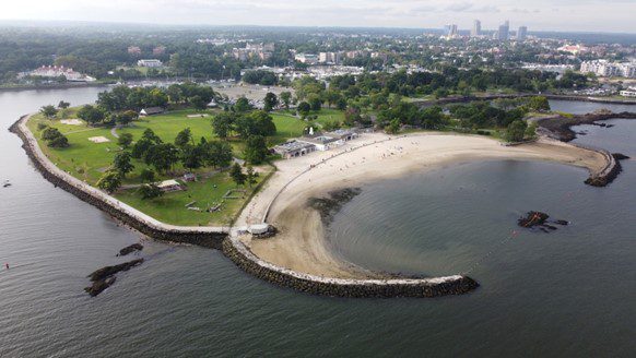
In 2023, Long Island Sound Study and Warren Pinnacle, in partnership with Westchester County and conservation groups/organizations, have developed a Plan to understand the benefits of, threats to, and recommended conservation actions for marsh ecosystems on Glen Island Park in New Rochelle, NY. The goal of the Plan is to help inform conservation and restoration efforts to maximize marsh ecosystem services under rising sea levels.
Sara Powell, slp285@cornell.edu
Case Study
In 2023, Long Island Sound Study and Warren Pinnacle, in partnership with Westchester County and conservation groups/organizations, have developed a Plan to understand the benefits of, threats to, and recommended conservation actions for marsh ecosystems on Glen Island Park in New Rochelle, NY. The goal of the Plan is to help inform conservation and restoration efforts to maximize marsh ecosystem services under rising sea levels.
Case Study
Old Saybrook, CT
The purpose of this project was to mitigate 450 ft of coastal erosion on the Long Island Sound. A part of Crab Creek was moved further inland, thus allowing for beach and dune migration over time. New rock sills, plants, and sand sills were also positioned along the shore.
Case Study
This public greenspace was suffering from mosquito overpopulation, invasion from Phragmites, and poor tidal/stormwater drainage. The Wetland’s Habitat and Mosquito Management Program (WHAMM) created a new drainage area and tunnels, while also eliminating invasive plants. Then organizations and volunteers banded together to remove and replace invasive plant species with native plants.
Juliana Barrett, CT Sea Grant Extension, 860-405-9106 & juliana.barrett@uconn.edu.
Case Study
This public greenspace was suffering from mosquito overpopulation, invasion from Phragmites, and poor tidal/stormwater drainage. The Wetland’s Habitat and Mosquito Management Program (WHAMM) created a new drainage area and tunnels, while also eliminating invasive plants. Then organizations and volunteers banded together to remove and replace invasive plant species with native plants.
Case Study
Stratford, CT
This project restored 46 acres of the Great Meadows Marsh in Connecticut that was degraded from dredge material that was dumped on site, poor drainage, and sea level rise. The marsh was also overrun with invasive plants and mosquitoes. A controlled fire was started to kill the invasive reeds growing in the marsh. Then a construction crew removed invasive plants and the dumped dredge material. Lastly, channels were carefully dug for tidal flushing which will allow the marsh to keep pace with sea level rise. Soil hummocks were constructed for Salt Marsh Sparrow habitat. Now the area continues to be monitored, assessed for resiliency, and provides a field for innovative solutions to be tested in.
Trustees: USFWS, NOAA, State of Connecticut; Project Partners: Audubon Connecticut, Town of Stratford


Molly Sperduto at molly_sperduto@fws.gov;
Corrie Folsom-O’Keefe cfolsom.okeefe@audubon.org;
Jack Matthias jack.matthias@audubon.org
Case Study
Stratford, CT
This project restored 46 acres of the Great Meadows Marsh in Connecticut that was degraded from dredge material that was dumped on site, poor drainage, and sea level rise. The marsh was also overrun with invasive plants and mosquitoes. A controlled fire was started to kill the invasive reeds growing in the marsh. Then a construction crew removed invasive plants and the dumped dredge material. Lastly, channels were carefully dug for tidal flushing which will allow the marsh to keep pace with sea level rise. Soil hummocks were constructed for Salt Marsh Sparrow habitat. Now the area continues to be monitored, assessed for resiliency, and provides a field for innovative solutions to be tested in.
Trustees: USFWS, NOAA, State of Connecticut; Project Partners: Audubon Connecticut, Town of Stratford
Case Study
Huntington, NY
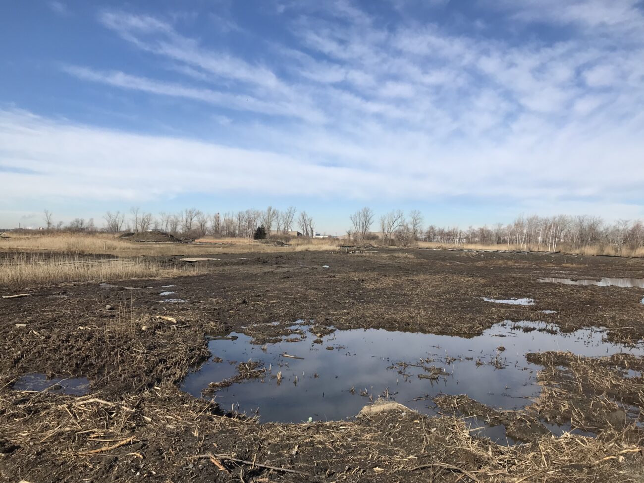
This comprehensive study and plan, funded through the National Fish and Wildlife Foundation, Long Island Sound Futures Fund, identifies initial strategies to maintain and enhance the local watershed resources of Crab Meadow. It is meant to be a land management tool to guide the implementation of best practices. The plan was developed in consultation with many partners and stakeholders. There is now significant community buy-in to take action to protect and restore this important watershed.
Following adoption of the plan, the Town of Huntington began working with US Fish and Wildlife Service and Audubon to study and restore Crab Meadow marsh and implement recommendations from the Stewardship Plan. Audubon, in partnership with Town of Huntington and USFWS, received a 2024 Long Island Sound Futures Fund Grant ($429K) to develop design plans for marsh restoration at Crab Meadow.
Garrett Chelius gchelius@huntingtonny.gov, Victoria O’Neill victoria.oneill@audubon.org, Suzanne Paton suzanne_paton@fws.gov
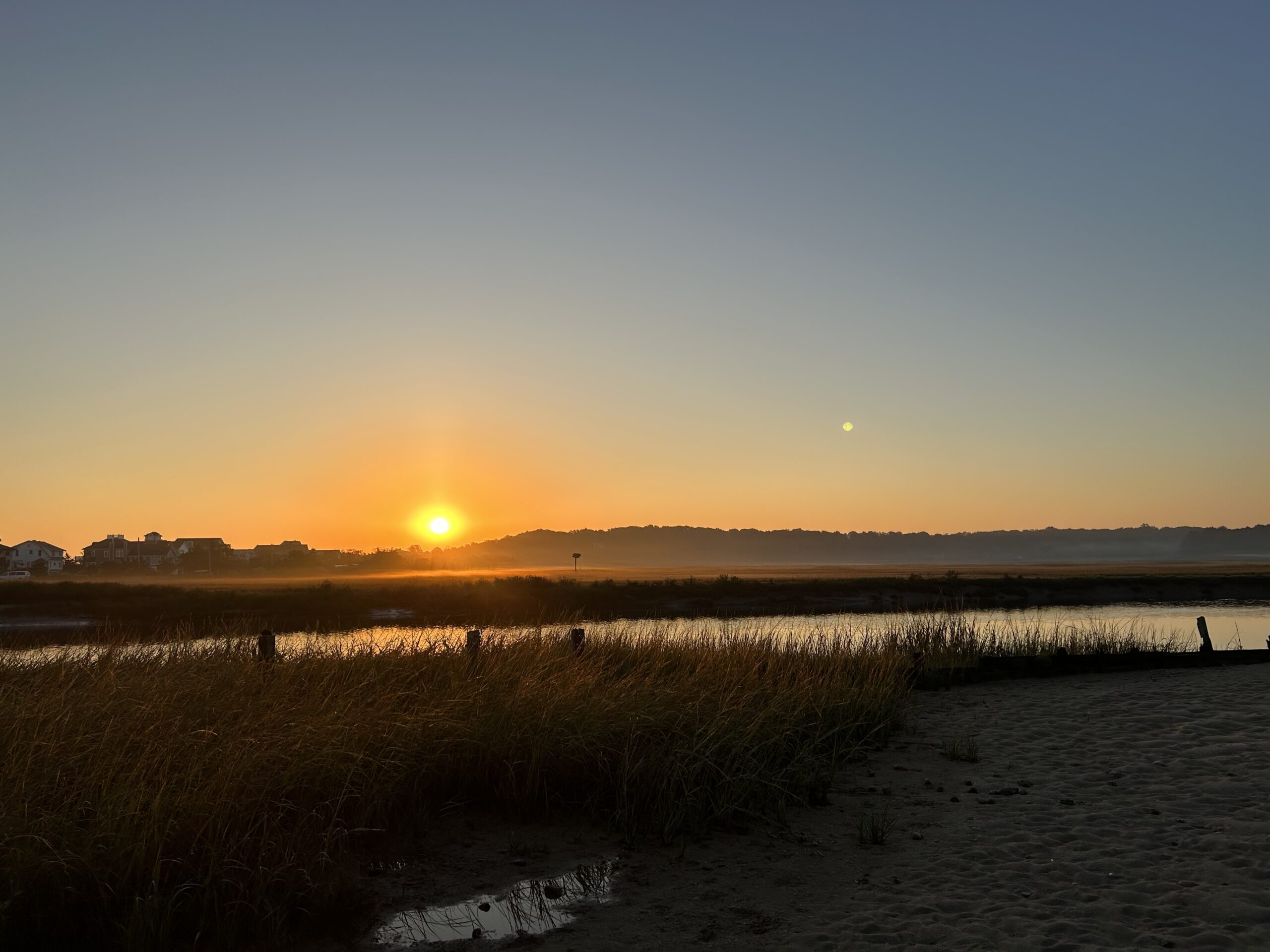 Photo by Jonah Saitz, USFWS.
Case Study
Huntington, NY
This comprehensive study and plan, funded through the National Fish and Wildlife Foundation, Long Island Sound Futures Fund, identifies initial strategies to maintain and enhance the local watershed resources of Crab Meadow. It is meant to be a land management tool to guide the implementation of best practices. The plan was developed in consultation with many partners and stakeholders. There is now significant community buy-in to take action to protect and restore this important watershed.
Following adoption of the plan, the Town of Huntington began working with US Fish and Wildlife Service and Audubon to study and restore Crab Meadow marsh and implement recommendations from the Stewardship Plan. Audubon, in partnership with Town of Huntington and USFWS, received a 2024 Long Island Sound Futures Fund Grant ($429K) to develop design plans for marsh restoration at Crab Meadow.
Case Study
Stony Brook, Head of Harbor and Nissequogue, NY
In 2023, Long Island Sound Study and Warren Pinnacle, in partnership with committed municipalities and conservation groups/organizations, developed a Plan to understand the benefits, threats, and recommended conservation actions for the Stony Brook Harbor and West Meadow Creek marsh ecosystem. The goal of the Plan is to help inform conservation and restoration efforts to maximize marsh ecosystem services under rising sea levels.

Elizabeth Hornstein, eeh78@cornell.edu
Case Study
Stony Brook, Head of Harbor and Nissequogue, NY
In 2023, Long Island Sound Study and Warren Pinnacle, in partnership with committed municipalities and conservation groups/organizations, developed a Plan to understand the benefits, threats, and recommended conservation actions for the Stony Brook Harbor and West Meadow Creek marsh ecosystem. The goal of the Plan is to help inform conservation and restoration efforts to maximize marsh ecosystem services under rising sea levels.
Case Study
Oyster Bay, NY and Cold Spring Harbor, NY
In 2023, Long Island Sound Study, New York Sea Grant and Warren Pinnacle, in partnership with committed municipalities and marsh-conservation groups/organizations, developed a Plan to understand the benefits, threats and recommended conservation actions at seven focal areas across the harbors. The goal of the Plan is to inform local municipalities and marsh-conservation groups as to where they might focus their conservation efforts to maximize the conservation of marsh ecosystem services under sea-level rise conditions. This process brought together a diversity of stakeholders to develop a cohesive strategy for seven focal areas across Oyster Bay and Cold Spring Harbor: Frost Creek, Mill Neck Creek, West Shore Road, Bayville Bridge to Centre Island, Centre Island, Shore Road, and Lower Cold Spring Harbor. The partners will now work to implement the recommendations in the plan.
St. John’s Episcopal Church (lower Cold Spring Harbor) and Village of Lattingtown (Frost Creek) were 2024 LIS Resilience Planning Support Program awardees. Their projects will build off the Oyster Bay & Cold Spring Harbor marsh conservation plan and develop specific recommendations to enhance and restore marsh habitat in lower Cold Spring Harbor and Frost Creek.

Sarah Schaefer-Brown, scs292@cornell.edu
Case Study
Oyster Bay, NY and Cold Spring Harbor, NY
In 2023, Long Island Sound Study, New York Sea Grant and Warren Pinnacle, in partnership with committed municipalities and marsh-conservation groups/organizations, developed a Plan to understand the benefits, threats and recommended conservation actions at seven focal areas across the harbors. The goal of the Plan is to inform local municipalities and marsh-conservation groups as to where they might focus their conservation efforts to maximize the conservation of marsh ecosystem services under sea-level rise conditions. This process brought together a diversity of stakeholders to develop a cohesive strategy for seven focal areas across Oyster Bay and Cold Spring Harbor: Frost Creek, Mill Neck Creek, West Shore Road, Bayville Bridge to Centre Island, Centre Island, Shore Road, and Lower Cold Spring Harbor. The partners will now work to implement the recommendations in the plan.
St. John’s Episcopal Church (lower Cold Spring Harbor) and Village of Lattingtown (Frost Creek) were 2024 LIS Resilience Planning Support Program awardees. Their projects will build off the Oyster Bay & Cold Spring Harbor marsh conservation plan and develop specific recommendations to enhance and restore marsh habitat in lower Cold Spring Harbor and Frost Creek.
Plan
The Superstorm Sandy Review Task Force conducted an in-depth review of the preparation for and response to Superstorm Sandy in Suffolk County by government agencies, first responders, nonprofits and private sector entities to determine which measures were effective and what actions must be taken in the future to increase resiliency and improve response to extreme weather events.
Story Map
Level of Effort:
This Story Map was developed to provide an overview of the Westchester County Multi-Jurisdictional Hazard Mitigation Plan (HMP) to facilitate county-wide access to the plan. The Westchester County HMP was developed to provide a roadmap to resilience by identifying hazards affecting the county and its communities.
Mapper
Level of Effort:
This mapper is intended to provide federal, state, and local managers with tools to estimate the vulnerability and ecosystem service potential of wetlands. It allows you to display information on the unvegetated to vegetated ratio (UVVR), marsh elevation, tidal range, and shoreline change rates for New York’s tidal wetlands.
Guidance Tool
Level of Effort:
The Coastal Science Navigator is intended to help users discover USGS Coastal Change Hazards information, products, and tools relevant to their scientific or decision-making needs.
Guidance Tool
Level of Effort:
The Coastal Science Navigator is intended to help users discover USGS Coastal Change Hazards information, products, and tools relevant to their scientific or decision-making needs.
Mapper
Level of Effort:
Coastal Resilience is a Connecticut-based decision support tool that provides local, regional, state and national stakeholders a step-wise process to guide decisions to reduce the ecological and socio-economic risks of coastal and inland hazards.
Mapper
Level of Effort:
Coastal Resilience is a Connecticut-based decision support tool that provides local, regional, state and national stakeholders a step-wise process to guide decisions to reduce the ecological and socio-economic risks of coastal and inland hazards.
Plan
Level of Effort:
Suffolk County and the local governments within Suffolk County developed a FEMA approved Hazard Mitigation Plan, which documents risks from natural hazards and strategies to mitigate hazards.
Plan
Level of Effort:
Suffolk County and the local governments within Suffolk County developed a FEMA approved Hazard Mitigation Plan, which documents risks from natural hazards and strategies to mitigate hazards.
Mapper
Level of Effort:
Developed by The Nature Conservancy, this tool identifies priority road-stream and tidal crossings in Suffolk County for replacement or upgrades. Prioritization is based on social and ecological criteria. Additionally, it includes data on current and future projected flooding and marsh extent under various sea level rise scenarios. The tool is meant to be a screening tool for planning efforts.
Mapper
Level of Effort:
RAPT provides access to important data and analysis tools to support your community before, during and after a disaster.
Mapper
Level of Effort:
RAPT provides access to important data and analysis tools to support your community before, during and after a disaster.
Mapper
Level of Effort:
Connecticut-specific site with maps, data, and visualization tools. Contains: Blue Plan, MS4 Viewer, CT Parcel Viewer, Sea Level Rise Effects on Roads & Marshes, CT DEEP Fish Community Data – Inland Waters, CT Aquaculture Mapping Atlas, CT Coastal Hazards Viewer, Carbon Stock & Land Cover Viewer
Mapper
Level of Effort:
Use this mapper to visualize people, infrastructure, and natural resources exposed to coastal flood hazards. You can save and share the online maps to communicate with stakeholders. Tip: watch the short video about the tool before getting started!
Mapper
Level of Effort:
Use this mapper to visualize people, infrastructure, and natural resources exposed to coastal flood hazards. You can save and share the online maps to communicate with stakeholders. Tip: watch the short video about the tool before getting started!
Mapper
Level of Effort:
This tool produces location-specific scenarios for sea level and flooding, as well as information about present-day and past conditions. Local governments and other practitioners can use the information to make informed decisions about strategic adaptation investments. The site incorporates data, maps, and visualizations and produces automated, location-specific reports.
Mapper
Level of Effort:
The Sea Level Affecting Marshes Model, or SLAMM, uses digital data and other information to simulate potential impacts of long-term sea level rise on wetlands and shorelines. Additional data related to dike locations or other protected areas, accretion rates, erosion rates, and other factors can be included within the model as optional factors. Requires ArcGIS for viewing outputs in a mapping environment and software, such as Microsoft Excel and Word, to view the text and tabular output.
Mapper
Level of Effort:
Use this web mapping tool to visualize community-level impacts from coastal flooding or sea level rise (up to 10 feet above average high tides). Photo simulations of how future flooding might impact local landmarks are also provided, as well as data related to water depth, connectivity, flood frequency, socio-economic vulnerability, wetland loss and migration, and mapping confidence.
Website
Level of Effort:
The 2022 State Climate Summaries provide new information on assessment topics directly related to NOAA’s mission, specifically historical climate variations and trends, future climate model projections of climate conditions during the 21st century, and past and future conditions of sea level and coastal flooding. Select your state to find state-level information for observed changes in climate, including both long-term trends and extreme weather events.
Story Map
Level of Effort:
This story map examines the coastal processes and hazards of Long Island and provides options for sustainable and resilient shoreline management. Information is useful for coastal managers, planners and coastal property owners.
Story Map
Level of Effort:
This story map examines the coastal processes and hazards of Long Island and provides options for sustainable and resilient shoreline management. Information is useful for coastal managers, planners and coastal property owners.
Data
Level of Effort:
New York State sea level rise projections. The New York State Department of Environmental Conservation is currently updating these projections.
Data
Level of Effort:
New York State sea level rise projections. The New York State Department of Environmental Conservation is currently updating these projections.
Mapper
Level of Effort:
This floodplain mapper shows the estimated boundary of future coastal floodplains for different sea level rise scenarios for New York State. Customize a scenario by choosing the amount of sea level rise in inches and a coastal flood recurrence interval.
Mapper
Level of Effort:
This floodplain mapper shows the estimated boundary of future coastal floodplains for different sea level rise scenarios for New York State. Customize a scenario by choosing the amount of sea level rise in inches and a coastal flood recurrence interval.
Guidance Tool
Level of Effort:
Provides information about coastal hazard management in Connecticut including steps for developing plans and responses.
Guidance Tool
Level of Effort:
Provides information about coastal hazard management in Connecticut including steps for developing plans and responses.
Data
Level of Effort:
Assess your county’s exposure and resilience to flooding and the potential economic impacts.
Data
Level of Effort:
Assess your county’s exposure and resilience to flooding and the potential economic impacts.
Guidance Tool
Level of Effort:
This website and the associated tools can be used by planners and engineers to help understand how rising sea levels, more intense storms, and heavy rainfalls affect stormwater systems, and to generate reports that can be used to inform planning.
Guidance Tool
Level of Effort:
This website and the associated tools can be used by planners and engineers to help understand how rising sea levels, more intense storms, and heavy rainfalls affect stormwater systems, and to generate reports that can be used to inform planning.
Website
Level of Effort:
MyCoast NY collects and catalogs photos provided by volunteers that document changing water levels, shorelines, and hazardous weather impacts across New York’s varied coasts and water bodies. Photos are linked to real-time environmental conditions to create flooding and storm impact reports that help stakeholders like government agencies, business owners, and residents understand our changing environment and make informed decisions.
Website
Level of Effort:
Submit your coastal flooding photos through this website/app. Photos are linked to real-time environmental conditions to create flooding reports that help stakeholders understand our changing environment and make informed decisions.
Website
Level of Effort:
Submit your coastal flooding photos through this website/app. Photos are linked to real-time environmental conditions to create flooding reports that help stakeholders understand our changing environment and make informed decisions.
Mapper
Level of Effort:
The purpose of the interactive viewer is to illustrate the fate of significant marsh systems on Long Island Sound under future Sea-Level Rise conditions. Model results are combined with tax-parcel information and integrated with information about marsh ecosystem services to assist municipalities and conservation groups in defining and assessing various land-management alternatives.
Data
Level of Effort:
Provides the most up-to-date sea level rise projections for all U.S. states and territories, out to the year 2150. Extrapolations of available tide gauge observations are also provided. The sea level scenarios and information contained in this tool originate from 2022 technical report produced by the Sea Level Rise and Coastal Flood Hazard Scenarios and Tools Interagency Task Force.
Story Map
Level of Effort:
This Story map illustrates climate change projections, considering scenarios that factor in temperature, precipitation, extreme heat, storms, and sea level.
Story Map
Level of Effort:
This Story map illustrates climate change projections, considering scenarios that factor in temperature, precipitation, extreme heat, storms, and sea level.
Mapper
Level of Effort:
Shows various SLR scenarios and flood event scenarios calibrated for the Long Island Sound CT coast. Also includes FEMA Limit of Moderate Wave Action boundary for referencing building codes.
Mapper
Level of Effort:
Shows various SLR scenarios and flood event scenarios calibrated for the Long Island Sound CT coast. Also includes FEMA Limit of Moderate Wave Action boundary for referencing building codes.
Mapper
Level of Effort:
Shows areas vulnerable to near-term flooding from different combinations of sea level rise, storm surge, tides, and tsunamis, or to permanent submersion by long-term sea level rise. Within the U.S., it incorporates the latest, high-resolution, high-accuracy lidar elevation data supplied by NOAA (exceptions: see Sources), displays points of interest, and contains layers displaying social vulnerability, population density, and property value.
Plan
Level of Effort:
Sea level preparation guidance for CT. Recommends planning for 20″ by 2050.
Plan
Level of Effort:
Sea level preparation guidance for CT. Recommends planning for 20″ by 2050.
Guidance Tool
Level of Effort:
This guide is designed to assist decision makers and coastal professionals with applying and integrating the information in the 2022 Sea Level Rise Technical Report, produced by the Sea Level Rise and Coastal Flood Hazard Scenarios and Tools Interagency Task Force, into local sea level rise planning and adaptation decisions.
Training
The second annual Long Island Sound Bi-State Sustainable and Resilient Communities Workshop brought together nearly 200 people virtually on Dec. 7, 2023 to learn about a new Long Island Sound Resilience Resource Hub (launching in early 2024), hear from communities and groups around the Sound working on resilience planning, and consider pathways for updating codes and ordinances. Videos of the workshop’s six sessions are available on YouTube. They can be accessed below along with supporting documents.
Training
Held at Locust Valley Library in Nassau County on May 4, 2023, this forum brought together state and local decision makers and other stakeholders, working to address coastal erosion along the Long Island Sound shoreline. Panelists highlighted strategies and options to address coastal erosion, discussed the Coastal Erosion Hazard Areas Program, local codes, updated New York State sea level rise projections and more. During small group discussions, attendees discussed challenges and identified opportunities to increase resilience, all in an effort to enhance coordination across communities. This forum was hosted by New York Sea Grant and Long Island Sound Study, in partnership with Nassau County Soil and Water Conservation District.
Training
Held at Port Jefferson Village Center in Suffolk County on May 10, 2023, this forum brought together state and local decision makers and other stakeholders, working to address coastal erosion along the Long Island Sound shoreline. Panelists highlighted strategies and options to address coastal erosion, discussed the Coastal Erosion Hazard Areas Program, local codes, updated New York State sea level rise projections and more. During small group discussions, attendees discussed challenges and identified opportunities to increase resilience, all in an effort to enhance coordination across communities. This forum was hosted by New York Sea Grant and Long Island Sound Study, in partnership with Suffolk County Soil and Water Conservation District and Suffolk County Legislators Sarah Anker, Stephanie Bontempi, Kara Hahn, and Al Krupski.
Training
These webinars were presented by NEIWPCC, Long Island Sound Study, and the New York State Department of Environmental Conservation. The webinars introduced the Marsh Interactive Fate Viewer, discussed the process of creating marsh conservation plans for Westchester County and Mattituck Creek (Suffolk County) in 2021, and laid the groundwork for developing additional marsh conservation plans over the course of 2023.
Training
This online information session held Sept. 19, and repeated Sept. 21, provides an introduction to resilience planning in the Long Island Sound region. It includes discussions on local climate impacts and projections, resilience planning strategies, and climate certification programs for both New York and Connecticut municipalities. In addition to the main presentation, videos of the Connecticut and New York breakout sessions can be accessed below. The presentations and other resource materials are available here.
Training
The first annual Long Island Sound Bi-State Sustainable and Resilient Communities Workshop brought together more than 260 people virtually on Dec. 1, 2022 to learn about opportunities to increase the resilience of the Sound’s communities to climate change and other environmental threats. Interactive sessions included opportunities to learn more about the SRC Extension Professionals’ needs assessment findings and recommendations, the newly released Long Island Sound Resilience Grant Writing Assistance Program, and tips for success with Long Island Sound funding opportunities. Concurrent breakout sessions highlighted the work of partners related to shoreline planning and implementation, using green infrastructure for stormwater management, sustainable climate planning for relocation, and new sustainability/resilience tools available in both New York and Connecticut. Videos of the workshop’s six sessions are available on YouTube. They can be accessed below along with supporting documents.
Training
In this Coastal Resiliency Network webinar, Jess Kuonen from NY Sea Grant presents on MyCoast New York, a portal used to collect and analyze photos of changing water levels, shorelines, and hazardous weather impacts across New York’s varied coasts and water bodies. Additionally, Nelson Vaz from the National Weather Service – NY shared the National Weather Service Coastal Flood Webpage resources and the benefits of collecting local impact information from sources such as MyCoast NY. The Coastal Resilience Network, led by the New York State Association of Conservation Commissions (NYSACC) with assistance from NY Sea Grant, is a collaborative open forum for communities in coastal Westchester, Nassau, and Suffolk Counties to discuss and learn about opportunities to increase their resilience to sea level rise, flooding, and extreme events.
Training
In this Coastal Resiliency Network webinar Suzette Lopane with Westchester County and Marian Russo with the Village of Patchogue spoke about two exciting living shoreline projects. The Coastal Resilience Network, led by the New York State Association of Conservation Commissions (NYSACC) with assistance from NY Sea Grant, is a collaborative open forum for communities in coastal Westchester, Nassau, and Suffolk Counties to discuss and learn about opportunities to increase their resilience to sea level rise, flooding, and extreme events.
Training
In this Coastal Resiliency Network webinar, Barbara Kendall from the NYS Department of State provides an overview of Local Waterfront Revitalization Programs (LWRP) and then representatives from four NYS coastal communities discuss their experiences developing and implementing their LWRPs. The Coastal Resilience Network, led by the New York State Association of Conservation Commissions (NYSACC) with assistance from NY Sea Grant, is a collaborative open forum for communities in coastal Westchester, Nassau, and Suffolk Counties to discuss and learn about opportunities to increase their resilience to sea level rise, flooding, and extreme events.
Training
In this Coastal Resiliency Network webinar, Samantha Klein, Environmental Analyst for the Town of East Hampton, discusses her experience in paving the way to a more resilient East Hampton with the development of their CARP (Coastal Assessment Resiliency Plan). She focuses on lessons learned, funding, and providing guidance on how to get started creating your own CARP. The Coastal Resilience Network, led by the New York State Association of Conservation Commissions (NYSACC) with assistance from NY Sea Grant, is a collaborative open forum for communities in coastal Westchester, Nassau, and Suffolk Counties to discuss and learn about opportunities to increase their resilience to sea level rise, flooding, and extreme events.
Resources & Tools

