Website
Level of Effort:
The New York State Climate Impacts Assessment explores current and future climate change impacts to New York State communities, ecosystems, and economy. The New York State Energy Research and Development Authority (NYSERDA) assembled more than 250 New York–based, national, and Indigenous climate science experts and representatives from diverse communities and industries across the state to contribute to this assessment. The findings are intended to help residents, businesses, and decision-makers across the state plan and prepare for climate change impacts.
remaining to apply
The New York State Environmental Facilities Corporation (EFC) is pleased to announce the availability of $60 million in grant funding through the inaugural round of the Green Resiliency Grant (GRG) program under the Clean Water, Clean Air and Green Jobs Environmental Bond Act of 2022 (Bond Act). The new program will prioritize grants to flood-prone communities and help them undertake innovative green infrastructure projects such as green roofs, green streets, and permeable pavement.
The New York State Environmental Facilities Corporation (EFC) is pleased to announce the availability of $60 million in grant funding through the inaugural round of the Green Resiliency Grant (GRG) program under the Clean Water, Clean Air and Green Jobs Environmental Bond Act of 2022 (Bond Act). The new program will prioritize grants to flood-prone communities and help them undertake innovative green infrastructure projects such as green roofs, green streets, and permeable pavement.
Funding
: Jul 26, 2024
remaining to apply
$500 - $1,000
Awards small grants in support of grassroots efforts and community-based environmental work in New England. The Grassroots Fund utilizes participatory grantmaking to move resources to New England grassroots groups working at the intersections of Environmental Justice. The program is geared toward groups who have some experience implementing a project in their community. Grants support groups to deepen their work by further developing a community vision, lowering barriers to participation, identifying new stakeholders, and working to bring more voices and lived experiences into core decision-making processes.
Funding
: Jul 26, 2024
$500 - $1,000
Awards small grants in support of grassroots efforts and community-based environmental work in New England. The Grassroots Fund utilizes participatory grantmaking to move resources to New England grassroots groups working at the intersections of Environmental Justice. The program is geared toward groups who have some experience implementing a project in their community. Grants support groups to deepen their work by further developing a community vision, lowering barriers to participation, identifying new stakeholders, and working to bring more voices and lived experiences into core decision-making processes.
Guidance Tool
Level of Effort:
This resource outlines six different federal mitigation funding programs. It provides an overview of available options and links to learn more information and apply.
Guidance Tool
Level of Effort:
This resource outlines six different federal mitigation funding programs. It provides an overview of available options and links to learn more information and apply.
Funding
: Mar 11 – Apr 14, 2024
remaining to apply
Congressionally Directed Spending requests, also known as Community Project Funding or Earmarks, are funding requests for high-impact, Connecticut-based projects that can be completed with assistance from the federal government. The project must meet the eligibility requirements for at least one of the accounts listed.
Funding
: Mar 11 – Apr 14, 2024
Congressionally Directed Spending requests, also known as Community Project Funding or Earmarks, are funding requests for high-impact, Connecticut-based projects that can be completed with assistance from the federal government. The project must meet the eligibility requirements for at least one of the accounts listed.
Funding
: Oct 12 – Dec 15, 2023
remaining to apply
$800M total available
The Flood Mitigation Assistance grant program is a competitive program that provides funding to states, federally recognized Tribal governments, U.S. territories, and local governments. Since the National Flood Insurance Reform Act of 1994 was signed into law, funds are used for projects that reduce or eliminate the risk of repetitive flood damage to buildings insured by the National Flood Insurance Program.
Funding
: Oct 12 – Dec 15, 2023
remaining to apply
$1B total available
The Federal Emergency Management Agency (FEMA) Building Resilient Infrastructure and Communities (BRIC) grant program will support states, local communities, tribes and territories as they undertake hazard mitigation projects, reducing the risks they face from disasters and natural hazards. The BRIC program’s guiding principles are to support communities through capability and capacity building, encourage and enable innovation; promote partnerships, enable large projects, maintain flexibility, and provide consistency.
Funding
: Oct 12 – Dec 15, 2023
$1B total available
The Federal Emergency Management Agency (FEMA) Building Resilient Infrastructure and Communities (BRIC) grant program will support states, local communities, tribes and territories as they undertake hazard mitigation projects, reducing the risks they face from disasters and natural hazards. The BRIC program’s guiding principles are to support communities through capability and capacity building, encourage and enable innovation; promote partnerships, enable large projects, maintain flexibility, and provide consistency.
Funding
: Nov 28 – Feb 24, 2024
remaining to apply
up to $50,000
The Climate Resilience Grant Program (CRGP) offers grants for projects that contribute to a world where people and nature can thrive. The goal of the program is to support partners in protecting the lands and waters critical for adapting to climate change. As climate change drives ecosystem instability, plants and animals are shifting their ranges northward. TNC has resources to support the conservation of climate resilient lands.
Funding
: Nov 28 – Feb 24, 2024
up to $50,000
The Climate Resilience Grant Program (CRGP) offers grants for projects that contribute to a world where people and nature can thrive. The goal of the program is to support partners in protecting the lands and waters critical for adapting to climate change. As climate change drives ecosystem instability, plants and animals are shifting their ranges northward. TNC has resources to support the conservation of climate resilient lands.
remaining to apply
$10-20M (Track 1), $1-3M (Track 2)
EPA is accepting applications on a rolling basis for $2 billion in Inflation Reduction Act funding available to support community-driven projects that build capacity for communities to tackle environmental and climate justice challenges, strengthen their climate resilience, and advance clean energy.
Guidance Tool
Level of Effort:
Guidance and training modules for Connecticut Zoning changes to address climate vulnerabilities. On the website there are examples of zoning policies municipalities could modify and/or adopt to enhance local climate resilience. Where applicable, model ordinances and examples of where the policies have been adopted are included.
Mapper
Level of Effort:
Connecticut EJ Screening Tool is an interactive resource that combines both community and data-driven approach that incorporates environmental burdens and demographic indicators. This map allows users to explore the environmental health and the conditions (socioeconomic and or other distinguishing community characteristics) within a specific region, town, city, and or entire state.
The data included in this map finalize into a score that allows users to understand the relationship between the community and environmental justice. Through the presentation of this information, citizens and policymakers alike can understand what communities are experiencing and form policies that reshape these matters.
Guidance Tool
Level of Effort:
The Federal Highway Administration (FHWA’s) Vulnerability Assessment and Adaptation Framework, 3rd Edition, is a guide and collection of resources for use in analyzing the impacts of climate change and extreme weather on transportation infrastructure. Its purpose is to identify key considerations, questions, and resources that can be used to design and implement a climate change vulnerability assessment. The processes, lessons learned, and resources outlined in the framework are geared toward state departments of transportation (DOTs), metropolitan planning organizations (MPOs), and other agencies involved in planning, building, or maintaining the transportation system. It includes suggestions and examples applicable to a wide range of applications, from small qualitative studies to large, detailed, data-intensive analyses. The resources included in the framework will be added to and updated over time.
Mapper
Level of Effort:
To better understand how Connecticut’s coastal area marshes and roads may respond to sea level rise (SLR), Sea Level Affecting Marshes Model (SLAMM) was applied to Connecticut’s shoreline by Warren Pinnacle Consulting, Inc. This viewer displays the model’s results for Connecticut’s 21 largest marshes and all coastal area roads. For marshes, SLAMM was run two hundred times using alternative model inputs for key model parameters, including various SLR scenarios, to produce probability based results of likely future marsh conditions. For roads, the model uses a single SLR scenario of about 4.2 feet by 2100 from the base year of 2002. The Sea Level Rise Effects on Roads and Marshes projects is a project between CT DEEP and UConn CLEAR.
Funding
: Jul 26, 2024
remaining to apply
Non-monetary Award
NYSDEC’s Trees for Tribs is a statewide program that works to reforest NY’s tributaries and create or improve riparian buffers that decrease erosion, reduce flooding damage, improve wildlife and stream habitat, and protect water quality.
Funding
: Jul 26, 2024
Non-monetary Award
NYSDEC’s Trees for Tribs is a statewide program that works to reforest NY’s tributaries and create or improve riparian buffers that decrease erosion, reduce flooding damage, improve wildlife and stream habitat, and protect water quality.
remaining to apply
Past awards have ranged from $25,000-$1,000,000, depending on project type and scale
The Agricultural Nonpoint Source Abatement and Control Program is a cost-share grant program that provides funding to address and prevent potential water quality issues that stem from farming activities. Financial and technical assistance supports the planning and implementation of on-farm projects with the goal of improving water quality in New York’s waterways.
remaining to apply
Past awards have ranged from $15,000-$825,000, depending on project type and scale
The Climate Resilient Farming program aims to reduce the impact of agriculture on climate change and to increase the resiliency of New York State farms in the face of a changing climate. The CRF grant program provides cost-share assistance to farmers to reduce GHG emissions and increase resiliency through Soil and Water Conservation Districts.
remaining to apply
Awards are based on reasonable costs to address the emergency.
Emergency financial assistance is available to municipalities for wastewater and drinking water system issues that pose hazards to public health, public welfare or the environment. The amount is based on the reasonable costs immediately necessary to address the emergency. The financial assistance is to be repaid within one year.
Assistance can be provided within two business days of a determination by the Department of Environmental Conservation (DEC) or Department of Health (DOH). Your will have to formally declare an emergency and submit an application.
Funding
: Jan 31, 2025
remaining to apply
$2,000-$10,000
Projects must meet one or more of the follow criteria in Nassau County:
a. Conserve or improve soils
b. Improve water quality of our groundwater and/or surface water
c. Control and prevent soil erosion and/or prevent floodwater and sediment damages
d. Conservation, development, utilization, and disposal of water
e. Preserve, increase, or improve natural resources including trees and plants
f. Control or eliminate invasive plants or wildlife
g. Control and abate NPS water pollution
h. Preserve wildlife
Funding
: Jan 31, 2025
$2,000-$10,000
Projects must meet one or more of the follow criteria in Nassau County:
a. Conserve or improve soils
b. Improve water quality of our groundwater and/or surface water
c. Control and prevent soil erosion and/or prevent floodwater and sediment damages
d. Conservation, development, utilization, and disposal of water
e. Preserve, increase, or improve natural resources including trees and plants
f. Control or eliminate invasive plants or wildlife
g. Control and abate NPS water pollution
h. Preserve wildlife
Funding
: Jul 26 – Jan 19, 2024
remaining to apply
Up to $1.5M for culvert projects and >$5M for bridge projects.
The BRIDGE NY Program provides enhanced assistance for local governments to rehabilitate and replace bridges and culverts on public highways/roadways. Particular emphasis will be provided for projects that address poor structural conditions; mitigate weight restrictions or detours; facilitate economic development or increase competitiveness; improve resiliency and/or reduce the risk of flooding. Priority consideration may also be given to projects that provide benefits to Environmental Justice Communities.
Funding
: Jul 26 – Jan 19, 2024
Up to $1.5M for culvert projects and >$5M for bridge projects.
The BRIDGE NY Program provides enhanced assistance for local governments to rehabilitate and replace bridges and culverts on public highways/roadways. Particular emphasis will be provided for projects that address poor structural conditions; mitigate weight restrictions or detours; facilitate economic development or increase competitiveness; improve resiliency and/or reduce the risk of flooding. Priority consideration may also be given to projects that provide benefits to Environmental Justice Communities.
remaining to apply
Max award of $50-75K
The Non-Agricultural Nonpoint Source Planning and MS4 Mapping Grant (NPG) is a competitive, reimbursement grant program that funds planning reports for nonpoint source water quality improvement projects and mapping of Municipal Separate Storm Sewer Systems (MS4s). The program aims to prepare nonpoint source projects for implementation funding, and to encourage and support cooperation among regulated MS4s to complete mapping of their stormwater system.
remaining to apply
The Water Quality Improvement Project (WQIP) program is a competitive, reimbursement grant program that funds projects that directly improve water quality or aquatic habitat, promote flood risk reduction, restoration, and enhanced flood and climate resiliency, or protect a drinking water source. Eligible project types includes: Wastewater Treatment Improvement, Nonagricultural Nonpoint Source Abatement and Control, Vacuum Trucks in Municipal Separate Storm Sewer System (MS4) Areas, Land Acquisition for Source Water Protection, Salt Storage, Dam Safety Repair/Rehabilitation, Aquatic Connectivity Restoration, and Marine Habitat Restoration.
The Water Quality Improvement Project (WQIP) program is a competitive, reimbursement grant program that funds projects that directly improve water quality or aquatic habitat, promote flood risk reduction, restoration, and enhanced flood and climate resiliency, or protect a drinking water source. Eligible project types includes: Wastewater Treatment Improvement, Nonagricultural Nonpoint Source Abatement and Control, Vacuum Trucks in Municipal Separate Storm Sewer System (MS4) Areas, Land Acquisition for Source Water Protection, Salt Storage, Dam Safety Repair/Rehabilitation, Aquatic Connectivity Restoration, and Marine Habitat Restoration.
remaining to apply
$50K-$2M for implementation grants, $10K-200K for certification grants
The Climate Smart Communities (CSC) Grant program was established in 2016 to provide 50/50 matching grants to cities, towns, villages, and counties of the State of New York for eligible climate change mitigation, adaptation, and planning and assessment projects. Funds are available for two broad project categories – implementation and certification. The first project category supports implementation projects related to the reduction of greenhouse gas emissions and climate change adaptation. The second supports planning and assessment projects aligned with NYS Climate Smart Communities certification actions.
remaining to apply
$50K-$3M
Local Waterfront Revitalization Program provides grants to municipalities along New York’s coasts or designated inland waterways to advance the preparation or implementation of strategies for community and waterfront revitalization through the following grant categories: 1) Preparing or Updating a Local Waterfront Revitalization Program (LWRP), 2) Updating an LWRP to be more Resilient to Climate Risk,s 3) Preparing an LWRP Component, including a Watershed Management Plan, and 4) Implementing a Local Waterfront Revitalization Program or a completed LWRP Component.
Funding
: Jul 26 – Jul 28, 2023
remaining to apply
Up to $3M
The Green Innovation Grant Program (GIGP) supports projects across New York State that utilize unique EPA-designated green stormwater infrastructure design and create cutting-edge green technologies. Competitive grants are awarded annually to projects that improve water quality and mitigate the effects of climate change through the implementation of one or more of the following green practices: Green Stormwater Infrastructure, Energy Efficiency, Water Efficiency and Environmental Innovation.
Funding
: Jul 26 – Jul 28, 2023
Up to $3M
The Green Innovation Grant Program (GIGP) supports projects across New York State that utilize unique EPA-designated green stormwater infrastructure design and create cutting-edge green technologies. Competitive grants are awarded annually to projects that improve water quality and mitigate the effects of climate change through the implementation of one or more of the following green practices: Green Stormwater Infrastructure, Energy Efficiency, Water Efficiency and Environmental Innovation.
Funding
: Apr 1 – Jun 7, 2024
remaining to apply
$50,000-$250,000
The Suffolk County Water Quality Improvement Division works to protect and improve Suffolk County’s ground and surface waters. The WQPRP provides funding to protect and restore surface and groundwater resources throughout the County. Funding is available for both planning/ engineering and construction expenses.
Funding
: Apr 1 – Jun 7, 2024
$50,000-$250,000
The Suffolk County Water Quality Improvement Division works to protect and improve Suffolk County’s ground and surface waters. The WQPRP provides funding to protect and restore surface and groundwater resources throughout the County. Funding is available for both planning/ engineering and construction expenses.
Funding
: Apr 14 – May 19, 2023
remaining to apply
varies by grant type
Through the Clean Water Fund, CT DEEP is able to provide grants and low-interest loans for infrastructure projects to meet clean water needs such as addressing combined sewer overflows, nutrient pollution, wastewater collection infrastructure needs, and projects using green infrastructure and addressing resiliency.
Funding
: Apr 14 – May 19, 2023
varies by grant type
Through the Clean Water Fund, CT DEEP is able to provide grants and low-interest loans for infrastructure projects to meet clean water needs such as addressing combined sewer overflows, nutrient pollution, wastewater collection infrastructure needs, and projects using green infrastructure and addressing resiliency.
Funding
: Jan 1 – Apr 15, 2023
remaining to apply
~$1,500
The EPOC Grant Program provides non-profit and not-for-profit environmental advocacy groups, community based groups and environmental education organizations funding for local projects that benefit the environment.
Funding
: Jan 1 – Apr 15, 2023
~$1,500
The EPOC Grant Program provides non-profit and not-for-profit environmental advocacy groups, community based groups and environmental education organizations funding for local projects that benefit the environment.
Funding
: Jul 26, 2024
remaining to apply
Up to $5000
Sustainable CT’s Community Match Fund is an innovative program that provides fast, flexible funding and support for engaging your community on wide-ranging sustainability projects. Eligible projects receive dollar-for-dollar matching funds from Sustainable CT.
Funding
: Jul 26, 2024
Up to $5000
Sustainable CT’s Community Match Fund is an innovative program that provides fast, flexible funding and support for engaging your community on wide-ranging sustainability projects. Eligible projects receive dollar-for-dollar matching funds from Sustainable CT.
Funding
: Nov 21 – Feb 8, 2024
remaining to apply
max $500,000
Grants are awarded for projects that address Nonpoint Source impacts in surface waters including creation and implementation of approved Watershed Based Plans.
Funding
: Nov 21 – Feb 8, 2024
max $500,000
Grants are awarded for projects that address Nonpoint Source impacts in surface waters including creation and implementation of approved Watershed Based Plans.
Funding
: Mar 20 – Sep 17, 2024
remaining to apply
$1,000 - $4,000
Awards small grants in support of grassroots efforts and community-based environmental work in New England. The Grassroots Fund utilizes participatory grantmaking to move resources to New England grassroots groups working at the intersections of Environmental Justice. The program is geared toward groups who have some experience implementing a project in their community. Grants support groups to deepen their work by further developing a community vision, lowering barriers to participation, identifying new stakeholders, and working to bring more voices and lived experiences into core decision-making processes.
Funding
: Mar 20 – Sep 17, 2024
$1,000 - $4,000
Awards small grants in support of grassroots efforts and community-based environmental work in New England. The Grassroots Fund utilizes participatory grantmaking to move resources to New England grassroots groups working at the intersections of Environmental Justice. The program is geared toward groups who have some experience implementing a project in their community. Grants support groups to deepen their work by further developing a community vision, lowering barriers to participation, identifying new stakeholders, and working to bring more voices and lived experiences into core decision-making processes.
Funding
: Jul 26 – Feb 27, 2024
remaining to apply
up to $2,000
The Connecticut Society for Women Environmental Professionals Grant Program provides funding for local projects in Connecticut that benefit the environment. Grants of up to $2,000 will be awarded. Any application meeting the grant guidelines that is not successful in one cycle may reapply during any following cycle. The applications will be judged based on the environmental benefits of each project, in comparison to others. “Environmental benefits” can vary widely and successful applications have ranged from property clean-ups to environmental education.
Funding
: Jul 26 – Feb 27, 2024
up to $2,000
The Connecticut Society for Women Environmental Professionals Grant Program provides funding for local projects in Connecticut that benefit the environment. Grants of up to $2,000 will be awarded. Any application meeting the grant guidelines that is not successful in one cycle may reapply during any following cycle. The applications will be judged based on the environmental benefits of each project, in comparison to others. “Environmental benefits” can vary widely and successful applications have ranged from property clean-ups to environmental education.
Funding
: Oct 24 – Feb 20, 2024
remaining to apply
$25,000 to $150,000
NOAA’s Bay Watershed Education and Training (B-WET) program is an environmental education program that promotes place-based experiential learning for K–12 students and related professional development for teachers.This funding opportunity focuses on projects combining long-term, classroom-integrated “Meaningful Watershed Educational Experiences” and capacity building for K-12 Environmental Literacy at the state and local level.
Funding
: Oct 24 – Feb 20, 2024
$25,000 to $150,000
NOAA’s Bay Watershed Education and Training (B-WET) program is an environmental education program that promotes place-based experiential learning for K–12 students and related professional development for teachers.This funding opportunity focuses on projects combining long-term, classroom-integrated “Meaningful Watershed Educational Experiences” and capacity building for K-12 Environmental Literacy at the state and local level.
Funding
: Nov 14 – Feb 2, 2024
remaining to apply
up to $10,000
The Green Fund seeks innovative proposals from committed organizations and individuals for activities that advance our mission which is to promote environmental quality, public health and equity in our community by providing grants and other incentives that contribute to a more environmentally sustainable future and reduce air, water and land pollution.
Funding
: Nov 14 – Feb 2, 2024
up to $10,000
The Green Fund seeks innovative proposals from committed organizations and individuals for activities that advance our mission which is to promote environmental quality, public health and equity in our community by providing grants and other incentives that contribute to a more environmentally sustainable future and reduce air, water and land pollution.
Funding
: Jun 12 – Oct 20, 2023
remaining to apply
not specified
The U.S. Army Corps of Engineers is launching a pilot program to fully fund small water resources projects for economically disadvantaged communities (based on the federal definition of disadvantaged communities (PDF)). This program was directed by Section 165 of the Water Resources Development Act (WRDA) of 2020. : Project proposals under this pilot program are for projects under the Continuing Authorities Program (CAP). Under CAP, the Corps can plan, design, and implement certain types of water resources projects without additional project specific congressional authorization. The purpose of the CAP is to plan and implement projects of limited size, cost, scope, and complexity. While CAP projects typically require a costshare with a non-Federal sponsor, this pilot program will fully fund the selected projects.
Funding
: Jun 12 – Oct 20, 2023
not specified
The U.S. Army Corps of Engineers is launching a pilot program to fully fund small water resources projects for economically disadvantaged communities (based on the federal definition of disadvantaged communities (PDF)). This program was directed by Section 165 of the Water Resources Development Act (WRDA) of 2020. : Project proposals under this pilot program are for projects under the Continuing Authorities Program (CAP). Under CAP, the Corps can plan, design, and implement certain types of water resources projects without additional project specific congressional authorization. The purpose of the CAP is to plan and implement projects of limited size, cost, scope, and complexity. While CAP projects typically require a costshare with a non-Federal sponsor, this pilot program will fully fund the selected projects.
Funding
: Apr 21 – Aug 18, 2023
remaining to apply
Min $100K for Planning Grants, $500K for Implementation
Established through the Bipartisan Infrastructure Law, the Promoting Resilient Operations for Transformative, Efficient, and Cost-Saving Transportation (PROTECT) Discretionary Grant Program aims to help make surface transportation more resilient to natural hazards, including climate change, sea level rise, flooding, extreme weather events, and other natural disasters. Funding is available for planning activities, resilience improvements, community resilience and evacuation routes, and at-risk costal infrastructure. Projects selected under this program should be grounded in the best available scientific understanding of climate change risks, impacts, and vulnerabilities, and should utilize innovative and collaborative approaches to risk reduction, including the use of nature-based solutions.
Funding
: Apr 21 – Aug 18, 2023
Min $100K for Planning Grants, $500K for Implementation
Established through the Bipartisan Infrastructure Law, the Promoting Resilient Operations for Transformative, Efficient, and Cost-Saving Transportation (PROTECT) Discretionary Grant Program aims to help make surface transportation more resilient to natural hazards, including climate change, sea level rise, flooding, extreme weather events, and other natural disasters. Funding is available for planning activities, resilience improvements, community resilience and evacuation routes, and at-risk costal infrastructure. Projects selected under this program should be grounded in the best available scientific understanding of climate change risks, impacts, and vulnerabilities, and should utilize innovative and collaborative approaches to risk reduction, including the use of nature-based solutions.
Funding
: Mar 10 – May 5, 2023
remaining to apply
$75,000 - $250,000 (~$800,000 total available- projected around 4-10 projects total)
The NEP Coastal Watersheds Grant Program is a nationally competitive grants program designed to support projects that address urgent and challenging issues threatening the well-being of coastal and estuarine areas within determined estuaries of national significance.
Funding
: Mar 10 – May 5, 2023
$75,000 - $250,000 (~$800,000 total available- projected around 4-10 projects total)
The NEP Coastal Watersheds Grant Program is a nationally competitive grants program designed to support projects that address urgent and challenging issues threatening the well-being of coastal and estuarine areas within determined estuaries of national significance.
Funding
: Jul 26 – Apr 20, 2023
remaining to apply
$200,000 - $5M depending on category
Intended to streamline grant funding opportunities for new conservation and restoration projects around the U.S., the America the Beautiful Challenge consolidates funding from multiple federal agencies and the private sector to enable applicants to conceive and develop large-scale projects that address shared funder priorities and span public and private lands.
Funding
: Jul 26 – Apr 20, 2023
$200,000 - $5M depending on category
Intended to streamline grant funding opportunities for new conservation and restoration projects around the U.S., the America the Beautiful Challenge consolidates funding from multiple federal agencies and the private sector to enable applicants to conceive and develop large-scale projects that address shared funder priorities and span public and private lands.
Funding
: Jul 26 – Apr 12, 2023
remaining to apply
$100,000 - $1,000,000
NFWF will award up to $140 million in grants to create and restore natural systems in order to increase protection for communities from coastal hazards, such as storms, sea- and lake-level changes, inundation, and coastal erosion, while improving habitats for fish and wildlife species. NFWF prioritizes projects that are community led or incorporate direct community engagement and benefit underserved communities facing disproportionate harm from climate impacts.
Funding
: Jul 26 – Apr 12, 2023
$100,000 - $1,000,000
NFWF will award up to $140 million in grants to create and restore natural systems in order to increase protection for communities from coastal hazards, such as storms, sea- and lake-level changes, inundation, and coastal erosion, while improving habitats for fish and wildlife species. NFWF prioritizes projects that are community led or incorporate direct community engagement and benefit underserved communities facing disproportionate harm from climate impacts.
remaining to apply
$150,000-$1M
There are four USDA programs that can support water and wastewater systems for disasters or mitigation:
1) Emergency Community Water Assistance Grants (ECWAG)
2) Water and Waste Disposal Loan and Grant Program
3) Special Evaluation Assistance for Rural Communities and Households
4) Revolving Funds for Financing Water and Wastewater Projects
Funding
: Jul 26, 2024
remaining to apply
$5M min (small communities) or $20M min (large communities)
The WIFIA program accelerates investment in our nation’s water infrastructure by providing long-term, low-cost supplemental loans for regionally and nationally significant projects. Managed out of USEPA Headquarters. Projects eligible for CWSRF would also be eligible for this loan.
Funding
: Jul 26, 2024
$5M min (small communities) or $20M min (large communities)
The WIFIA program accelerates investment in our nation’s water infrastructure by providing long-term, low-cost supplemental loans for regionally and nationally significant projects. Managed out of USEPA Headquarters. Projects eligible for CWSRF would also be eligible for this loan.
Funding
: Mar 1 – May 13, 2024
remaining to apply
$50K - $1.5M
The Long Island Sound Futures Fund (LISFF) will be seeking proposals to restore the health and living resources of Long Island Sound (Sound) with approximately $12 million in funding in 2024. The program is managed by National Fish and Wildlife Foundation (NFWF) in collaboration with the U.S. Environmental Protection Agency (EPA) and the Long Island Sound Study (LISS). Major funding is from EPA through the LISS with additional funding from the U.S. Fish and Wildlife Service and the Avangrid Foundation.
Funding
: Mar 1 – May 13, 2024
$50K - $1.5M
The Long Island Sound Futures Fund (LISFF) will be seeking proposals to restore the health and living resources of Long Island Sound (Sound) with approximately $12 million in funding in 2024. The program is managed by National Fish and Wildlife Foundation (NFWF) in collaboration with the U.S. Environmental Protection Agency (EPA) and the Long Island Sound Study (LISS). Major funding is from EPA through the LISS with additional funding from the U.S. Fish and Wildlife Service and the Avangrid Foundation.
Funding
: Oct 12 – Jan 23, 2024
remaining to apply
$1B total available
The Federal Emergency Management Agency (FEMA) Building Resilient Infrastructure and Communities (BRIC) grant program will support states, local communities, tribes and territories as they undertake hazard mitigation projects, reducing the risks they face from disasters and natural hazards. The BRIC program’s guiding principles are to support communities through capability and capacity building, encourage and enable innovation; promote partnerships, enable large projects, maintain flexibility, and provide consistency.
Funding
: Oct 12 – Jan 23, 2024
remaining to apply
$800M total available
The Flood Mitigation Assistance grant program is a competitive program that provides funding to states, federally recognized Tribal governments, U.S. territories, and local governments. Since the National Flood Insurance Reform Act of 1994 was signed into law, funds are used for projects that reduce or eliminate the risk of repetitive flood damage to buildings insured by the National Flood Insurance Program.
Funding
: Oct 12 – Jan 23, 2024
$800M total available
The Flood Mitigation Assistance grant program is a competitive program that provides funding to states, federally recognized Tribal governments, U.S. territories, and local governments. Since the National Flood Insurance Reform Act of 1994 was signed into law, funds are used for projects that reduce or eliminate the risk of repetitive flood damage to buildings insured by the National Flood Insurance Program.
Funding
: Sep 27 – Dec 1, 2023
remaining to apply
$5,000-$100,000
EPA Long Island Sound Study announced a new Environmental Justice (EJ) program focused on the Long Island Sound watershed. The Long Island Sound Community Impact Fund (LISCIF) will direct funds and technical assistance to communities experiencing or affected by adverse and disproportionate environmental and human health risks or harms.
Funding
: Sep 27 – Dec 1, 2023
$5,000-$100,000
EPA Long Island Sound Study announced a new Environmental Justice (EJ) program focused on the Long Island Sound watershed. The Long Island Sound Community Impact Fund (LISCIF) will direct funds and technical assistance to communities experiencing or affected by adverse and disproportionate environmental and human health risks or harms.
Case Study
East Haddam, CT
With support from the Nature Conservancy and Sustainable CT, East Haddam organized a Community Resilience Building process and workshop, the results of which were compiled into this summary. The team engaged with community members to determine the present hazards and vulnerabilities and identify resilient solutions.
Case Study
Increased development and the historic construction of a dam on Sunken Meadow Creek in the 1950’s led to reduced tidal exchange, increased water levels in the creek, poor water quality, and the proliferation of invasive species. In 2008 a number of partners (NYS OPRHP, NOAA, NYSDEC, LISS, TNC, Save the Sound, USFWS, LI Botanical Society) came together to work to restore the degraded marsh habitat around Sunken Meadow Creek, increase tidal flow, improve aquatic organism passage, limit invasives, and improve water quality. A restoration feasibility study was completed in 2010. In 2012 Superstorm Sandy blew out the dam on Sunken Meadow Creek, naturally kick-starting restoration. Following Superstorm Sandy, the project partners were able to quickly capitalize on available funding and grants, due to their prior planning efforts. A bridge was built across the Creek where the dam blew out, salt marsh habitat was restored at three locations, green infrastructure was installed in one of the parking areas to capture and treat stormwater runoff, fish passage feasibility on the creek was investigated, and education and outreach was conducted to thousands of people. These projects were completed in 2019. Now, with funding through Long Island Sound Futures Fund, Audubon NY is leading a large-scale marsh restoration project at Sunken Meadow Creek to restore important high-marsh habitat for at risk species, like the Saltmarsh Sparrow, and to increase the resilience of the marsh in the face of rising sea levels. Audubon will be working to finalize the designs and secure permits over the next two years, with on-the-ground restoration expected in 2026.


Sean Cruickshank Sean.Cruickshank@parks.ny.gov, Jon Vander Werff jvanderwerff@savethesound.org, Phoebe Clark phoebe.clark@audubon.org, Vicky O’Neill victoria.oneill@audubon.org
Case Study
Increased development and the historic construction of a dam on Sunken Meadow Creek in the 1950’s led to reduced tidal exchange, increased water levels in the creek, poor water quality, and the proliferation of invasive species. In 2008 a number of partners (NYS OPRHP, NOAA, NYSDEC, LISS, TNC, Save the Sound, USFWS, LI Botanical Society) came together to work to restore the degraded marsh habitat around Sunken Meadow Creek, increase tidal flow, improve aquatic organism passage, limit invasives, and improve water quality. A restoration feasibility study was completed in 2010. In 2012 Superstorm Sandy blew out the dam on Sunken Meadow Creek, naturally kick-starting restoration. Following Superstorm Sandy, the project partners were able to quickly capitalize on available funding and grants, due to their prior planning efforts. A bridge was built across the Creek where the dam blew out, salt marsh habitat was restored at three locations, green infrastructure was installed in one of the parking areas to capture and treat stormwater runoff, fish passage feasibility on the creek was investigated, and education and outreach was conducted to thousands of people. These projects were completed in 2019. Now, with funding through Long Island Sound Futures Fund, Audubon NY is leading a large-scale marsh restoration project at Sunken Meadow Creek to restore important high-marsh habitat for at risk species, like the Saltmarsh Sparrow, and to increase the resilience of the marsh in the face of rising sea levels. Audubon will be working to finalize the designs and secure permits over the next two years, with on-the-ground restoration expected in 2026.
Case Study
Huntington, NY
This comprehensive study and plan, funded through the National Fish and Wildlife Foundation, Long Island Sound Futures Fund, identifies initial strategies to maintain and enhance the local watershed resources of Crab Meadow. It is meant to be a land management tool to guide the implementation of best practices. The plan was developed in consultation with many partners and stakeholders.
Garrett Chelius gchelius@huntingtonny.gov

Case Study
Huntington, NY
This comprehensive study and plan, funded through the National Fish and Wildlife Foundation, Long Island Sound Futures Fund, identifies initial strategies to maintain and enhance the local watershed resources of Crab Meadow. It is meant to be a land management tool to guide the implementation of best practices. The plan was developed in consultation with many partners and stakeholders.
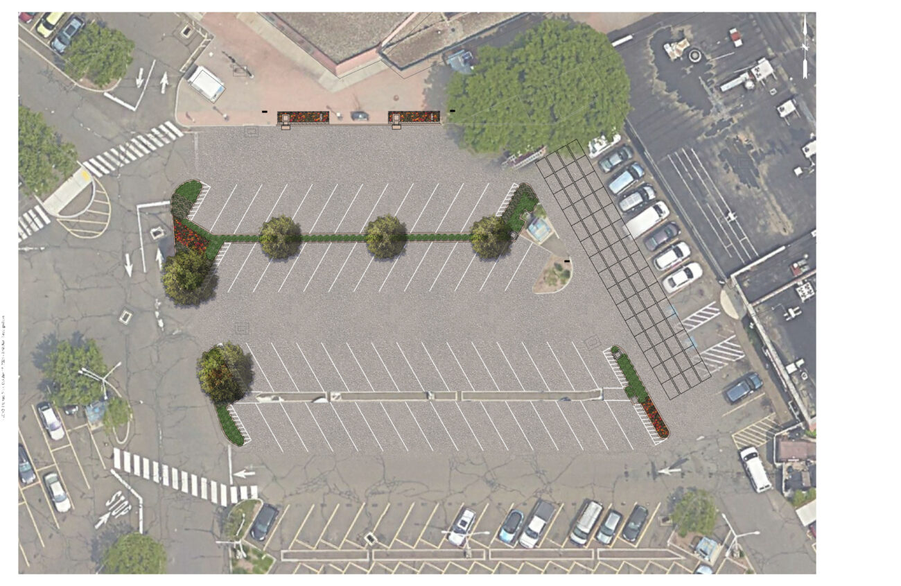
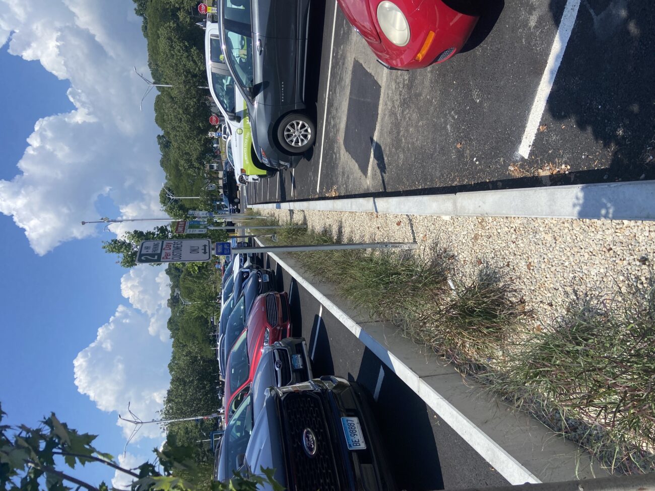
Case Study
Norwalk, CT
In 2019, the City of Norwalk secured a LIS Future Fund grant to install green infrastructure in the Webster Street Parking to reduce the impacts of stormwater on the Norwalk River and Harbor and mitigate local flooding of surrounding businesses through the installation of four different types of infiltration and bio-retention structures:
1) Underground infiltration systems.
2) Retention basins and curb inlet planters in eight different areas.
3) Porous pavement with storage in two areas.
4) Infiltration gutters and tree filters in two other areas.


Bryan Lutz
Assistant Director of Parking
blutz@norwalkct.gov; 203-854-7253
Case Study
Norwalk, CT
In 2019, the City of Norwalk secured a LIS Future Fund grant to install green infrastructure in the Webster Street Parking to reduce the impacts of stormwater on the Norwalk River and Harbor and mitigate local flooding of surrounding businesses through the installation of four different types of infiltration and bio-retention structures:
1) Underground infiltration systems.
2) Retention basins and curb inlet planters in eight different areas.
3) Porous pavement with storage in two areas.
4) Infiltration gutters and tree filters in two other areas.
Case Study
Stratford, CT
This project restored 46 acres of the Great Meadows Marsh in Connecticut that was degraded from dredge material that was dumped on site, poor drainage, and sea level rise. The marsh was also overrun with invasive plants and mosquitoes. A controlled fire was started to kill the invasive reeds growing in the marsh. Then a construction crew removed invasive plants and the dumped dredge material. Lastly, channels were carefully dug for tidal flushing which will allow the marsh to keep pace with sea level rise. Soil hummocks were constructed for Salt Marsh Sparrow habitat. Now the area continues to be monitored, assessed for resiliency, and provides a field for innovative solutions to be tested in.
Trustees: USFWS, NOAA, State of Connecticut; Project Partners: Audubon Connecticut, Town of Stratford


Molly Sperduto at molly_sperduto@fws.gov;
Corrie Folsom-O’Keefe cfolsom.okeefe@audubon.org;
Jack Matthias jack.matthias@audubon.org
Case Study
Stratford, CT
This project restored 46 acres of the Great Meadows Marsh in Connecticut that was degraded from dredge material that was dumped on site, poor drainage, and sea level rise. The marsh was also overrun with invasive plants and mosquitoes. A controlled fire was started to kill the invasive reeds growing in the marsh. Then a construction crew removed invasive plants and the dumped dredge material. Lastly, channels were carefully dug for tidal flushing which will allow the marsh to keep pace with sea level rise. Soil hummocks were constructed for Salt Marsh Sparrow habitat. Now the area continues to be monitored, assessed for resiliency, and provides a field for innovative solutions to be tested in.
Trustees: USFWS, NOAA, State of Connecticut; Project Partners: Audubon Connecticut, Town of Stratford
Case Study
Wilton, CT
Dana Dam (aka Strong Pond Dam) at Merwin Meadows Park in Wilton, CT was the first barrier to upstream fish migration from Long Island Sound on the Norwalk River. A series of dams along the Norwalk River (historically, and presently) prevented fish from reaching their historic spawning grounds, have posed safety risks, and disconnected the river from its natural floodplain. On September 11, 2023, demolition of this dam began! In addition to restoring habitat and allowing fish passage, the removal restored natural floodplain connectivity, realigned 200 feet of river channel away from an active railroad embankment, and removed a known safety hazard.


Alex Krofta, akrofta@savethesound.org
Case Study
Wilton, CT
Dana Dam (aka Strong Pond Dam) at Merwin Meadows Park in Wilton, CT was the first barrier to upstream fish migration from Long Island Sound on the Norwalk River. A series of dams along the Norwalk River (historically, and presently) prevented fish from reaching their historic spawning grounds, have posed safety risks, and disconnected the river from its natural floodplain. On September 11, 2023, demolition of this dam began! In addition to restoring habitat and allowing fish passage, the removal restored natural floodplain connectivity, realigned 200 feet of river channel away from an active railroad embankment, and removed a known safety hazard.
Case Study
New Haven, CT
The City of New Haven has installed 286 right-of-way bioswales throughout the city as part of a multifaceted approach to reducing flooding in the downtown area. Right-of-way bioswales are engineered planted areas that are located on sidewalks. They are designed to capture and infiltrate stormwater into the ground that would otherwise directly enter a storm drain. These bioswales were installed as the result of various partnerships and funding opportunities related to flood prevention, localized drainage solutions, combined sewer overflow mitigation, research, and traffic calming projects.
City of New Haven, Dept of Engineering
Urban Resources Initiative, EMERGE Inc., Save the Sound, Yale School of the Environment, and Quinnipiac University, among others.

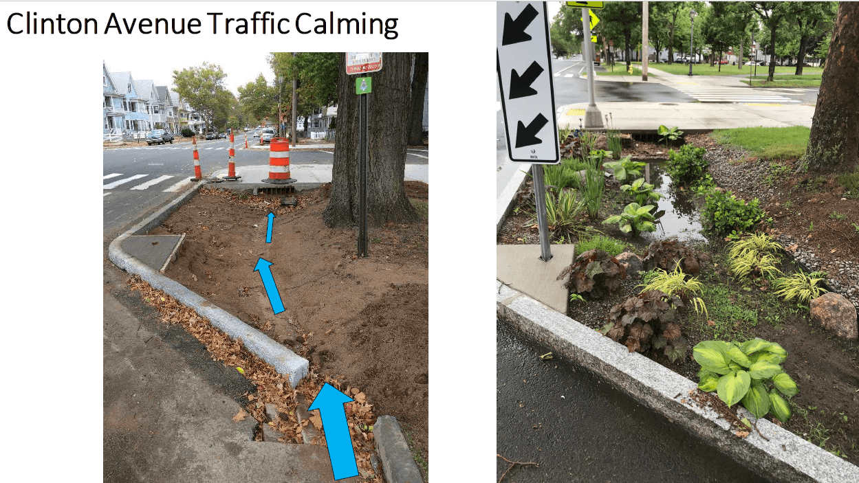

Dawn Henning
dhenning@newhavenct.gov
475-434-1643
Case Study
New Haven, CT
The City of New Haven has installed 286 right-of-way bioswales throughout the city as part of a multifaceted approach to reducing flooding in the downtown area. Right-of-way bioswales are engineered planted areas that are located on sidewalks. They are designed to capture and infiltrate stormwater into the ground that would otherwise directly enter a storm drain. These bioswales were installed as the result of various partnerships and funding opportunities related to flood prevention, localized drainage solutions, combined sewer overflow mitigation, research, and traffic calming projects.
City of New Haven, Dept of Engineering
Urban Resources Initiative, EMERGE Inc., Save the Sound, Yale School of the Environment, and Quinnipiac University, among others.
Case Study
This public greenspace was suffering from mosquito overpopulation, invasion from Phragmites, and poor tidal/stormwater drainage. The Wetland’s Habitat and Mosquito Management Program (WHAMM) created a new drainage area and tunnels, while also eliminating invasive plants. Then organizations and volunteers banded together to remove and replace invasive plant species with native plants.
Juliana Barrett, CT Sea Grant Extension, 860-405-9106 & juliana.barrett@uconn.edu.
Case Study
This public greenspace was suffering from mosquito overpopulation, invasion from Phragmites, and poor tidal/stormwater drainage. The Wetland’s Habitat and Mosquito Management Program (WHAMM) created a new drainage area and tunnels, while also eliminating invasive plants. Then organizations and volunteers banded together to remove and replace invasive plant species with native plants.
Case Study
Old Saybrook, CT
The purpose of this project was to mitigate 450 ft of coastal erosion on the Long Island Sound. A part of Crab Creek was moved further inland, thus allowing for beach and dune migration over time. New rock sills, plants, and sand sills were also positioned along the shore.
Guidance Tool
Level of Effort:
The New York State Department of State worked with the Department of Environmental Conservation and other partners to create model local laws to help local governments be more resilient to sea-level rise, storm surge, and flooding. Cities, towns, and villages are invited to adapt model local laws to meet the resilience needs of the community with the assistance of their municipal attorneys.
Guidance Tool
Level of Effort:
This document developed in support of the NYS Community Risk and Resiliency Act 1) Describes natural resilience measures and how they can be used to mitigate the risks of flooding and erosion, 2) Provides definitions for different types of natural resilience measures and distinguishes among conserved, restored, nature-based and hard structural approaches, 3) Provides information on the value and benefits of using natural resilience measures, along with information on the co-benefits they provide, 4) Lists key factors to consider in the restoration, design and construction of natural resilience measures, and 5) Provides background to support the development of NYS agency guidance on natural resilience measures in the future
Website
Level of Effort:
ReduceFloodRisk.org was developed by the Association of State Floodplain Managers to help property owners and buyers in flood prone areas identify strategies to reduce their properties risk of flooding.
Website
Level of Effort:
ReduceFloodRisk.org was developed by the Association of State Floodplain Managers to help property owners and buyers in flood prone areas identify strategies to reduce their properties risk of flooding.
Mapper
Level of Effort:
Developed by The Nature Conservancy, this tool identifies priority road-stream and tidal crossings in Suffolk County for replacement or upgrades. Prioritization is based on social and ecological criteria. Additionally, it includes data on current and future projected flooding and marsh extent under various sea level rise scenarios. The tool is meant to be a screening tool for planning efforts.
Plan
Level of Effort:
Suffolk County and the local governments within Suffolk County developed a FEMA approved Hazard Mitigation Plan, which documents risks from natural hazards and strategies to mitigate hazards.
Plan
Level of Effort:
Suffolk County and the local governments within Suffolk County developed a FEMA approved Hazard Mitigation Plan, which documents risks from natural hazards and strategies to mitigate hazards.
Guidance Tool
Level of Effort:
The Coastal Science Navigator is intended to help users discover USGS Coastal Change Hazards information, products, and tools relevant to their scientific or decision-making needs.
Guidance Tool
Level of Effort:
The Coastal Science Navigator is intended to help users discover USGS Coastal Change Hazards information, products, and tools relevant to their scientific or decision-making needs.
Story Map
Level of Effort:
This Story Map was developed to provide an overview of the Westchester County Multi-Jurisdictional Hazard Mitigation Plan (HMP) to facilitate county-wide access to the plan. The Westchester County HMP was developed to provide a roadmap to resilience by identifying hazards affecting the county and its communities.
Plan
The Superstorm Sandy Review Task Force conducted an in-depth review of the preparation for and response to Superstorm Sandy in Suffolk County by government agencies, first responders, nonprofits and private sector entities to determine which measures were effective and what actions must be taken in the future to increase resiliency and improve response to extreme weather events.
Mapper
Level of Effort:
The CCVI combines built, social, and ecological factors to identify areas that are vulnerable to flooding and heat related impacts of climate change. These mapping tools can be used to view vulnerability at both a regional scale and at specific sites to see how factors are contributing.
Website
Level of Effort:
Contains guidance documents and information on coastal permitting from the State of Connecticut.
Website
Level of Effort:
Contains guidance documents and information on coastal permitting from the State of Connecticut.
Guidance Tool
Level of Effort:
Provides information about coastal hazard management in Connecticut including steps for developing plans and responses.
Guidance Tool
Level of Effort:
Provides information about coastal hazard management in Connecticut including steps for developing plans and responses.
Guidance Tool
Level of Effort:
A centralized source of information for municipal officials, coastal property owners, state coastal managers, and the general public on coastal hazards in Connecticut.
Guidance Tool
Level of Effort:
A centralized source of information for municipal officials, coastal property owners, state coastal managers, and the general public on coastal hazards in Connecticut.
Mapper
Level of Effort:
Connecticut-specific site with maps, data, and visualization tools. Contains: Blue Plan, MS4 Viewer, CT Parcel Viewer, Sea Level Rise Effects on Roads & Marshes, CT DEEP Fish Community Data – Inland Waters, CT Aquaculture Mapping Atlas, CT Coastal Hazards Viewer, Carbon Stock & Land Cover Viewer
Website
Level of Effort:
The Connecticut Shoreline Change Project analyzes how the Connecticut shoreline has changed between the late 1800’s and 2006 through loss (erosion) and gain (accretion) over time.
Website
Level of Effort:
The Connecticut Shoreline Change Project analyzes how the Connecticut shoreline has changed between the late 1800’s and 2006 through loss (erosion) and gain (accretion) over time.
Story Map
Level of Effort:
This Story map illustrates climate change projections, considering scenarios that factor in temperature, precipitation, extreme heat, storms, and sea level.
Story Map
Level of Effort:
This Story map illustrates climate change projections, considering scenarios that factor in temperature, precipitation, extreme heat, storms, and sea level.
Story Map
Level of Effort:
This story map illustrates historical hurricane tracks, strike frequency, and potential areas of coastal flooding and inundation from storms.
Story Map
Level of Effort:
This story map illustrates historical hurricane tracks, strike frequency, and potential areas of coastal flooding and inundation from storms.
Mapper
Level of Effort:
The site includes updated design storm rainfall amounts. Includes estimates of extreme rainfall for various durations (from 5 minutes to 10 days) and recurrence intervals (1 year to 500 years). Regional extreme rainfall maps and graphic products are also available. This updates existing analyses to account for changes such as the increasing frequency of heavy rainfall events.
Guidance Tool
Level of Effort:
The primary goal of this guide is to help communities identify and engage the staff and resources that can be used to implement nature-based solutions to build resilience to natural hazards, which may be exacerbated by climate change.
Guidance Tool
Level of Effort:
The primary goal of this guide is to help communities identify and engage the staff and resources that can be used to implement nature-based solutions to build resilience to natural hazards, which may be exacerbated by climate change.
Guidance Tool
Level of Effort:
This guide gives community leaders five main strategies to carry out Nature-Based Solution projects: 1) Building Strong Partnerships, 2) Engaging the Whole Community, 3) Matching Project Size With Desired Goals and Benefits, 4) Maximizing Benefits, and 5) Designing for the Future. This is not a technical guide for planning, constructing or funding NBS. It covers the value of each strategy and suggests how to move forward with NBS projects.
Incentive Program
The Community Rating System (CRS) is a voluntary incentive program that recognizes and encourages community floodplain management practices that exceed the minimum requirements of the National Flood Insurance Program (NFIP).
Incentive Program
The Community Rating System (CRS) is a voluntary incentive program that recognizes and encourages community floodplain management practices that exceed the minimum requirements of the National Flood Insurance Program (NFIP).
Mapper
Level of Effort:
The FEMA Flood Map Service Center (MSC) is the official public source for flood hazard information produced in support of the National Flood Insurance Program (NFIP). Use the MSC to find your official flood map.
Mapper
Level of Effort:
The FEMA Flood Map Service Center (MSC) is the official public source for flood hazard information produced in support of the National Flood Insurance Program (NFIP). Use the MSC to find your official flood map.
Mapper
Level of Effort:
These community profiles are intended to be used by municipal officials and planners working to make their communities more economically, environmentally, and socially resilient. Includes datasets related to FEMA disaster and non-disaster funding, flood insurance claims, social vulnerability, and other community stats.
Mapper
Level of Effort:
RAPT provides access to important data and analysis tools to support your community before, during and after a disaster.
Mapper
Level of Effort:
RAPT provides access to important data and analysis tools to support your community before, during and after a disaster.
Guidance Tool
Level of Effort:
This toolkit features legal and policy tools, best and emerging practices, and case studies to support learning and decision making around managed retreat and climate adaptation. It is meant to be used by state, territorial, and local policymakers in U.S. coastal jurisdictions
Mapper
Level of Effort:
The purpose of the interactive viewer is to illustrate the fate of significant marsh systems on Long Island Sound under future Sea-Level Rise conditions. Model results are combined with tax-parcel information and integrated with information about marsh ecosystem services to assist municipalities and conservation groups in defining and assessing various land-management alternatives.
Website
Level of Effort:
Submit your coastal flooding photos through this website/app. Photos are linked to real-time environmental conditions to create flooding reports that help stakeholders understand our changing environment and make informed decisions.
Website
Level of Effort:
Submit your coastal flooding photos through this website/app. Photos are linked to real-time environmental conditions to create flooding reports that help stakeholders understand our changing environment and make informed decisions.
Website
Level of Effort:
MyCoast NY collects and catalogs photos provided by volunteers that document changing water levels, shorelines, and hazardous weather impacts across New York’s varied coasts and water bodies. Photos are linked to real-time environmental conditions to create flooding and storm impact reports that help stakeholders like government agencies, business owners, and residents understand our changing environment and make informed decisions.
Plan
Level of Effort:
The Nassau County Hazard Mitigation Plan was developed through a year-long interactive planning process in close coordination with stakeholders. The process included identifying the hazards of concern within the County, assessing those hazards, estimating risk, and developing a strategy to mitigate risk to these hazards throughout the County.
Mapper
Level of Effort:
Neighborhoods at Risk is an easy-to-use website with interactive maps, charts, and resources to help communities identify neighborhoods that may be more impacted by climate change. It shows where people may experience unequal impacts from flooding and extreme heat.
Mapper
Level of Effort:
Neighborhoods at Risk is an easy-to-use website with interactive maps, charts, and resources to help communities identify neighborhoods that may be more impacted by climate change. It shows where people may experience unequal impacts from flooding and extreme heat.
Guidance Tool
Level of Effort:
This website and the associated tools can be used by planners and engineers to help understand how rising sea levels, more intense storms, and heavy rainfalls affect stormwater systems, and to generate reports that can be used to inform planning.
Guidance Tool
Level of Effort:
This website and the associated tools can be used by planners and engineers to help understand how rising sea levels, more intense storms, and heavy rainfalls affect stormwater systems, and to generate reports that can be used to inform planning.
Data
Level of Effort:
Assess your county’s exposure and resilience to flooding and the potential economic impacts.
Data
Level of Effort:
Assess your county’s exposure and resilience to flooding and the potential economic impacts.
Mapper
Level of Effort:
Use this mapper to visualize people, infrastructure, and natural resources exposed to coastal flood hazards. You can save and share the online maps to communicate with stakeholders. Tip: watch the short video about the tool before getting started!
Mapper
Level of Effort:
Use this mapper to visualize people, infrastructure, and natural resources exposed to coastal flood hazards. You can save and share the online maps to communicate with stakeholders. Tip: watch the short video about the tool before getting started!
Mapper
Level of Effort:
Use this guide to walk through the process of how to calculate and plot coastal flood frequency. Primary intended audience: planners, engineers, etc. This guide outlines steps for calculating customized scenarios of local coastal flood frequencies using the same methods as NOAA’s Sea Level Rise Viewer. The tool uses flood threshold data from the National Weather Service and the Inundation Analysis Tool from NOAA’s Center for Operational Oceanographic Products and Services.
Mapper
Level of Effort:
The Sea Level Affecting Marshes Model, or SLAMM, uses digital data and other information to simulate potential impacts of long-term sea level rise on wetlands and shorelines. Additional data related to dike locations or other protected areas, accretion rates, erosion rates, and other factors can be included within the model as optional factors. Requires ArcGIS for viewing outputs in a mapping environment and software, such as Microsoft Excel and Word, to view the text and tabular output.
Mapper
Level of Effort:
Use this web mapping tool to visualize community-level impacts from coastal flooding or sea level rise (up to 10 feet above average high tides). Photo simulations of how future flooding might impact local landmarks are also provided, as well as data related to water depth, connectivity, flood frequency, socio-economic vulnerability, wetland loss and migration, and mapping confidence.
Website
Level of Effort:
The 2022 State Climate Summaries provide new information on assessment topics directly related to NOAA’s mission, specifically historical climate variations and trends, future climate model projections of climate conditions during the 21st century, and past and future conditions of sea level and coastal flooding. Select your state to find state-level information for observed changes in climate, including both long-term trends and extreme weather events.
Story Map
Level of Effort:
This story map examines the coastal processes and hazards of Long Island and provides options for sustainable and resilient shoreline management. Information is useful for coastal managers, planners and coastal property owners.
Story Map
Level of Effort:
This story map examines the coastal processes and hazards of Long Island and provides options for sustainable and resilient shoreline management. Information is useful for coastal managers, planners and coastal property owners.
Mapper
Level of Effort:
This mapper, developed through the New York Climate Act, was developed by the State Climate Justice Working Group to identify disadvantaged communities to ensure that frontline and otherwise underserved communities benefit from the state’s historic transition to cleaner, greener sources of energy, reduced pollution and cleaner air, and economic opportunities. The interactive map identifies areas throughout the State that meet the disadvantaged community Criteria as defined by the Climate Justice Working Group.
Mapper
Level of Effort:
This floodplain mapper shows the estimated boundary of future coastal floodplains for different sea level rise scenarios for New York State. Customize a scenario by choosing the amount of sea level rise in inches and a coastal flood recurrence interval.
Mapper
Level of Effort:
This floodplain mapper shows the estimated boundary of future coastal floodplains for different sea level rise scenarios for New York State. Customize a scenario by choosing the amount of sea level rise in inches and a coastal flood recurrence interval.
Guidance Tool
Level of Effort:
Aimed at municipalities, this website provides workshop materials and legal issue fact sheets on topics relating to climate adaptation, including living shorelines, flooding, liability, shoreline boundaries, and more.
Guidance Tool
Level of Effort:
Aimed at municipalities, this website provides workshop materials and legal issue fact sheets on topics relating to climate adaptation, including living shorelines, flooding, liability, shoreline boundaries, and more.
Guidance Tool
Level of Effort:
Website (also available as a PDF) to help coastal property owners evaluate threats to beaches and dunes and consider potential solutions. It includes background information on dune systems, and how to identify shoreline erosion.
Guidance Tool
Level of Effort:
Website (also available as a PDF) to help coastal property owners evaluate threats to beaches and dunes and consider potential solutions. It includes background information on dune systems, and how to identify shoreline erosion.
Guidance Tool
Level of Effort:
This guide is designed to assist decision makers and coastal professionals with applying and integrating the information in the 2022 Sea Level Rise Technical Report, produced by the Sea Level Rise and Coastal Flood Hazard Scenarios and Tools Interagency Task Force, into local sea level rise planning and adaptation decisions.
Mapper
Level of Effort:
Shows various SLR scenarios and flood event scenarios calibrated for the Long Island Sound CT coast. Also includes FEMA Limit of Moderate Wave Action boundary for referencing building codes.
Mapper
Level of Effort:
Shows various SLR scenarios and flood event scenarios calibrated for the Long Island Sound CT coast. Also includes FEMA Limit of Moderate Wave Action boundary for referencing building codes.
Mapper
Level of Effort:
Shows areas vulnerable to near-term flooding from different combinations of sea level rise, storm surge, tides, and tsunamis, or to permanent submersion by long-term sea level rise. Within the U.S., it incorporates the latest, high-resolution, high-accuracy lidar elevation data supplied by NOAA (exceptions: see Sources), displays points of interest, and contains layers displaying social vulnerability, population density, and property value.
Training
The second annual Long Island Sound Bi-State Sustainable and Resilient Communities Workshop brought together nearly 200 people virtually on Dec. 7, 2023 to learn about a new Long Island Sound Resilience Resource Hub (launching in early 2024), hear from communities and groups around the Sound working on resilience planning, and consider pathways for updating codes and ordinances. Videos of the workshop’s six sessions are available on YouTube. They can be accessed below along with supporting documents.
Training
In this Coastal Resiliency Network webinar, Samantha Klein, Environmental Analyst for the Town of East Hampton, discusses her experience in paving the way to a more resilient East Hampton with the development of their CARP (Coastal Assessment Resiliency Plan). She focuses on lessons learned, funding, and providing guidance on how to get started creating your own CARP. The Coastal Resilience Network, led by the New York State Association of Conservation Commissions (NYSACC) with assistance from NY Sea Grant, is a collaborative open forum for communities in coastal Westchester, Nassau, and Suffolk Counties to discuss and learn about opportunities to increase their resilience to sea level rise, flooding, and extreme events.
Training
In this Coastal Resiliency Network webinar, Barbara Kendall from the NYS Department of State provides an overview of Local Waterfront Revitalization Programs (LWRP) and then representatives from four NYS coastal communities discuss their experiences developing and implementing their LWRPs. The Coastal Resilience Network, led by the New York State Association of Conservation Commissions (NYSACC) with assistance from NY Sea Grant, is a collaborative open forum for communities in coastal Westchester, Nassau, and Suffolk Counties to discuss and learn about opportunities to increase their resilience to sea level rise, flooding, and extreme events.
Resources & Tools

