
Resilience Steps
Find support and resources tailored to your project needs. Select your Planning Phase, Location, and/or Topic of interest to access a filtered selection of our curated resources and tools.

Learn
Learn about the environmental threats and climate risks in your community

Plan
Identify strategies to help mitigate risks and develop ways to adapt to a changing climate

Implement
Find funding and guidance to help put your plans into action

Sustain
Monitor, maintain, and adaptively-manage your project to sustain success
Filters
Select one or more of the filters below to find relevant tools and resources for your needs
Need help deciding where to start?
Learn how to identify, prioritize, and implement high-impact projects

Resource
Long Island Watershed Action Agenda
The Long Island Watershed Action Agenda is a clear-cut blueprint for water quality improvements, aquatic habitat conservation, groundwater protection, and the public engagement necessary to ensure success for the surface, coastal, and ground waters of Nassau and Suffolk counties. The Long Island Watershed Action Agenda is an evolution of the success of the Long Island Nitrogen Action Plan (LINAP) and will expand the scope of its work beyond nitrogen reduction.
Mapper
Level of Effort:
NYC Stormwater Flood Maps
The NYC Stormwater Flood Maps show areas in New York City that are at risk of flooding during heavy rain. The tool provides interactive maps that let users explore neighborhood-level flood risk and understand how stormwater might affect streets, homes, and critical infrastructure. It helps residents, planners, and local organizations identify vulnerable areas and make decisions about preparedness, emergency planning, and long-term resilience.
These maps also bring together important environmental and social data, making it easier to compare neighborhoods, see patterns, and understand which communities may face the greatest challenges during extreme weather.
Report
Level of Effort:
Severe Weather Mitigation & Resiliency Advisory Council – Final Report 2025
Connecticut’s Severe Weather Mitigation and Resiliency Advisory Council was created to help the state better prepare for the growing risks of hurricanes, flooding, and other severe weather events. According to the Council and the CT Insurance Department, many Connecticut homes especially older buildings or houses in coastal and urban areas are highly vulnerable to wind and flood damage. The Council’s final report explains that severe weather is becoming more expensive for families, and many residents lack the insurance or financial resources to recover after storms. To address this, the Council recommends strengthening partnerships with programs like Energize CT, Habitat for Humanity, and the CT Green Bank, and promoting upgrades such as IBHS Fortified™ roofs, which can reduce damage from high winds. They also emphasize the need for public education about flood risk, insurance awareness, and preparedness, along with long-term actions like statewide grant programs, tax credits, and expanded training for contractors and evaluators. Together, these efforts aim to help Connecticut residents protect their homes, reduce storm damage, and build a safer, more resilient future.
You can view the complete Final Report (2025) in PDF format
Data
Level of Effort:
Climate Central: Local Climate Information Tool
Search your city or state to learn the many ways a warming world is affecting your place now.
Explore these pages to learn how people in your local area are at risk in a warming world.
Find local data regarding temperatures, precipitation, sea level rise, storms, and more.
Browse climate-related graphics for all seasons localized for your area, that are available for download.
Data
Level of Effort:
SCRCOG Municipal Data Dashboard
The South Central Regional Council of Governments (SCRCOG) has created an interactive data dashboard. This dashboard allows users to explore, visualize, and download regional data to support informed decision-making. Scroll down on the page and use the left/right arrows to access the information and visualizations.
Mapper
Level of Effort:
Connecticut Environmental Justice Screening Tool
Connecticut EJ Screening Tool is an interactive resource that combines both community and data-driven approach that incorporates environmental burdens and demographic indicators. This map allows users to explore the environmental health and the conditions (socioeconomic and or other distinguishing community characteristics) within a specific region, town, city, and or entire state.
The data included in this map finalize into a score that allows users to understand the relationship between the community and environmental justice. Through the presentation of this information, citizens and policymakers alike can understand what communities are experiencing and form policies that reshape these matters.
Website
Level of Effort:
NYSDOH Extreme Heat Resources
Information from the NYS Department of Health (DOH) on extreme heat impacts and resources for the public.
Website
Level of Effort:
NYSDOH Extreme Heat Resources
Information from the NYS Department of Health (DOH) on extreme heat impacts and resources for the public.
Plan
Level of Effort:
Suffolk County Hazard Mitigation Plan
Suffolk County and the local governments within Suffolk County developed a FEMA approved Hazard Mitigation Plan, which documents risks from natural hazards and strategies to mitigate hazards.
Plan
Level of Effort:
Suffolk County Hazard Mitigation Plan
Suffolk County and the local governments within Suffolk County developed a FEMA approved Hazard Mitigation Plan, which documents risks from natural hazards and strategies to mitigate hazards.
Story Map
Level of Effort:
Westchester County Hazard Mitigation Plan Story Map
This Story Map was developed to provide an overview of the Westchester County Multi-Jurisdictional Hazard Mitigation Plan (HMP) to facilitate county-wide access to the plan. The Westchester County HMP was developed to provide a roadmap to resilience by identifying hazards affecting the county and its communities.
Mapper
Level of Effort:
NYSDEC Shellfish Mapper
This NYSDEC tool provides information on shellfish closures in NY’s marine waters and can be used to help resource users understand where it is safe to harvest to shellfish.
Mapper
Level of Effort:
NYSDEC Shellfish Mapper
This NYSDEC tool provides information on shellfish closures in NY’s marine waters and can be used to help resource users understand where it is safe to harvest to shellfish.
Guidance Tool
Level of Effort:
Climate Essentials for Emergency Managers (FEMA)
This document offers foundational learning opportunities for the emergency management community and beyond. By sharing communication techniques, climate information, data resources, and guidance for connecting with experts, this resource helps advance the integration of climate change considerations into actionable efforts before, during, and after disasters.
Guidance Tool
Level of Effort:
Climate Change and Extreme Heat
This booklet from the EPA and CDC summarizes why extreme heat is on the rise, how it might affect people, and outlines steps to prepare for extreme heat events to reduce health risks.
Guidance Tool
Level of Effort:
Climate Change and Extreme Heat
This booklet from the EPA and CDC summarizes why extreme heat is on the rise, how it might affect people, and outlines steps to prepare for extreme heat events to reduce health risks.
Mapper
Level of Effort:
NYS Disadvantaged Communities Map
This mapper, developed through the New York Climate Act, was developed by the State Climate Justice Working Group to identify disadvantaged communities to ensure that frontline and otherwise underserved communities benefit from the state’s historic transition to cleaner, greener sources of energy, reduced pollution and cleaner air, and economic opportunities. The interactive map identifies areas throughout the State that meet the disadvantaged community Criteria as defined by the Climate Justice Working Group.
Story Map
Level of Effort:
NY Sea Grant Long Island Dynamic Shorelines
This story map examines the coastal processes and hazards of Long Island and provides options for sustainable and resilient shoreline management. Information is useful for coastal managers, planners and coastal property owners.
Story Map
Level of Effort:
NY Sea Grant Long Island Dynamic Shorelines
This story map examines the coastal processes and hazards of Long Island and provides options for sustainable and resilient shoreline management. Information is useful for coastal managers, planners and coastal property owners.
Website
Level of Effort:
Brownfield Coalition of the Northeast
A platform with resources by state for brownfield remediation, resilience, and sustainable redevelopment.
Website
Level of Effort:
Brownfield Coalition of the Northeast
A platform with resources by state for brownfield remediation, resilience, and sustainable redevelopment.
Guidance Tool
Level of Effort:
An Extreme Heat Toolkit for Connecticut Municipalities
Provides resources that help Connecticut’s municipal leaders fill gaps in local
extreme heat planning including
1. Communication templates
2. Cooling center best practices
3. A diverse collection of policy and planning actions
4. Advice on creating a heat response plan
Also provides Connecticut-specific information on how extreme heat impacts the
health of residents, especially vulnerable people, and extreme heat safety tips.
Mapper
Level of Effort:
Resilience and Adaptation in New England (RAINE) Database
Explore a range of tools and guidance to support climate adaptation planning through EPA New England’s Resilience and Adaptation in New England (RAINE) initiative, which supports users in exploring climate resilience planning across the New England. These resources include more than 1,200 climate adaptation plans. Practitioners can use the Featured Locations Interactive Map to view climate action examples or explore additional climate visualization platforms through the Mapping Climate Change Impacts Tools page. The database also highlights Tribal Climate Adaptation Resources, featuring plans from federally recognized tribes in New England. Users can view recorded webinars and trainings for technical guidance.
Mapper
Level of Effort:
Climate Risk Mapping Tool for Connecticut Residents
Connecticut Insurance Department CID, in Collaboration with First Street Foundation, provides climate related risk mapping tool for Connecticut residents. This tool allows users to search Connecticut property addresses to view maps and reports that provide detailed property-specific climate risk assessments, particularly for flood, wildfire, extreme heat, and hurricane wind hazards. This free risk mapping tool allows homeowners, home buyers, small-business owners, and community leaders to identify the risks using state-of-the-art climate risk mapping technology.
Data
Level of Effort:
NYC Hazard Mitigation Plan
This website contains New York City’s Federal Emergency Management Agency–mandated Hazard Mitigation Plan, which identifies natural hazard risks and vulnerabilities that are common to New York City (NYC) and long-term strategies for reducing them. It also features a Mitigation Actions Database and Map that tracks and records actions that are taken to mitigate risk from the hazards profiled in the Hazard Mitigation Plan.
Mapper
Level of Effort:
Coastal Risk Finder
A product of Climate Central’s Sea Level Program, Coastal Risk Finder allows users to get local flood projections, understand who and what is at risk in their communities, and learn about solutions for coastal states, counties, cities, towns, congressional districts, and state legislative districts in the contiguous U.S., with more to come. Users can download data and graphics to further their local adaptation and communication efforts related to coastal flooding. Coastal Risk Finder includes detailed briefs on adaptation efforts in coastal states and territories, providing insights into policies, projects, and key organizations working to mitigate flood risks. By highlighting actionable solutions, we aim to empower communities with the knowledge and tools needed to address coastal flooding challenges.
The accompanying User Guides highlight the most useful features and provide guidance on using the tool for specific applications. A recording of the Launch Webinar featuring expert insights is also available.
Mapper
Level of Effort:
5th National Climate Assessment Atlas
NCA5 Atlas
To help Americans anticipate how changing climate conditions might affect their homes and businesses, the United States Global Change Research Program conducts a comprehensive review of scientific information on climate trends and impacts in our country every four years. The 5th National Climate Assessment — often referred to as NCA5 — was published in 2023.
This Interactive Atlas provides access to data compiled for NCA5. Browse the collection for your own investigations, or access the data for custom analysis and mapping.
Report
Level of Effort:
The Fifth National Climate Assessment
The Fifth National Climate Assessment is the US Government’s preeminent report on climate change impacts, risks, and responses. It is a congressionally mandated interagency effort that provides the scientific foundation to support informed decision-making across the United States.
Website
Level of Effort:
New York State Climate Impacts Assessment: Understanding and Preparing for Our Changing Climate
The New York State Climate Impacts Assessment explores current and future climate change impacts to New York State communities, ecosystems, and economy. The New York State Energy Research and Development Authority (NYSERDA) assembled more than 250 New York–based, national, and Indigenous climate science experts and representatives from diverse communities and industries across the state to contribute to this assessment. The findings are intended to help residents, businesses, and decision-makers across the state plan and prepare for climate change impacts.
Report
Level of Effort:
Connecticut Physical Climate Science Assessment Report (PCSAR)
This study by Seth et al. provides up-to-date information on observed trends and projections of temperature and precipitation in Connecticut.
Report
Level of Effort:
Connecticut Physical Climate Science Assessment Report (PCSAR)
This study by Seth et al. provides up-to-date information on observed trends and projections of temperature and precipitation in Connecticut.
Mapper
Level of Effort:
Neighborhoods At Risk
Neighborhoods at Risk is an easy-to-use website with interactive maps, charts, and resources to help communities identify neighborhoods that may be more impacted by climate change. It shows where people may experience unequal impacts from flooding and extreme heat.
Plan
Level of Effort:
Nassau County Hazard Mitigation Plan
The Nassau County Hazard Mitigation Plan was developed through a year-long interactive planning process in close coordination with stakeholders. The process included identifying the hazards of concern within the County, assessing those hazards, estimating risk, and developing a strategy to mitigate risk to these hazards throughout the County.
Mapper
Level of Effort:
FEMA Resilience Analysis and Planning Tool (RAPT)
RAPT provides access to important data and analysis tools to support your community before, during and after a disaster.
Mapper
Level of Effort:
FEMA Resilience Analysis and Planning Tool (RAPT)
RAPT provides access to important data and analysis tools to support your community before, during and after a disaster.
Mapper
Level of Effort:
Connecticut Environmental Conditions Online (CTEco) — CTDEEP & CLEAR
Connecticut-specific site with maps, data, and visualization tools. Contains: Blue Plan, MS4 Viewer, CT Parcel Viewer, Sea Level Rise Effects on Roads & Marshes, CT DEEP Fish Community Data – Inland Waters, CT Aquaculture Mapping Atlas, CT Coastal Hazards Viewer, Carbon Stock & Land Cover Viewer
Mapper
Level of Effort:
Climate Change Vulnerability Index (CIRCA)
The CCVI combines built, social, and ecological factors to identify areas that are vulnerable to flooding and heat related impacts of climate change. These mapping tools can be used to view vulnerability at both a regional scale and at specific sites to see how factors are contributing.
Mapper
Level of Effort:
The Long Island Sound and Watershed Metadata Map Application
The Long Island Sound watershed is home to nearly 9 million people in parts of Connecticut, Massachusetts, New Hampshire, New York, Rhode Island, Vermont, and Canada. Government agencies, nonprofits, and Tribal Nations have overseen numerous projects to monitor and protect the water resources of this watershed and the sound. Although there is an abundance of data, there is no easy way to search them or a central place to manage this information. To help, the U.S. Geological Survey, the U.S. Environmental Protection Agency, and the Long Island Sound Study have created an interactive map to help users find and understand data about the water resources of the Long Island Sound and its watershed.
This mapping tool does not host data or maintain data repositories. Instead, it compiles and presents metadata from publicly accessible databases managed by State and other organizations.
Refer to this fact sheet for details about the application and its data sources: The Long Island Sound and Watershed Metadata map application
Guidance Tool
Level of Effort:
NOAA Digital Coast – Ecosystem Services
Healthy ecosystems provide a wide range of benefits, from recreational opportunities to storm surge protection. These benefits are often referred to as ecosystem services. Understanding how changes to the ecosystem may affect these benefits should play a role in the community’s decision making process. This page provides a guide to learning more and key NOAA Digital Coast resources useful for this task.
SRC Training
Nassau County Coastal Resilience Forum & Field Trip – 2025
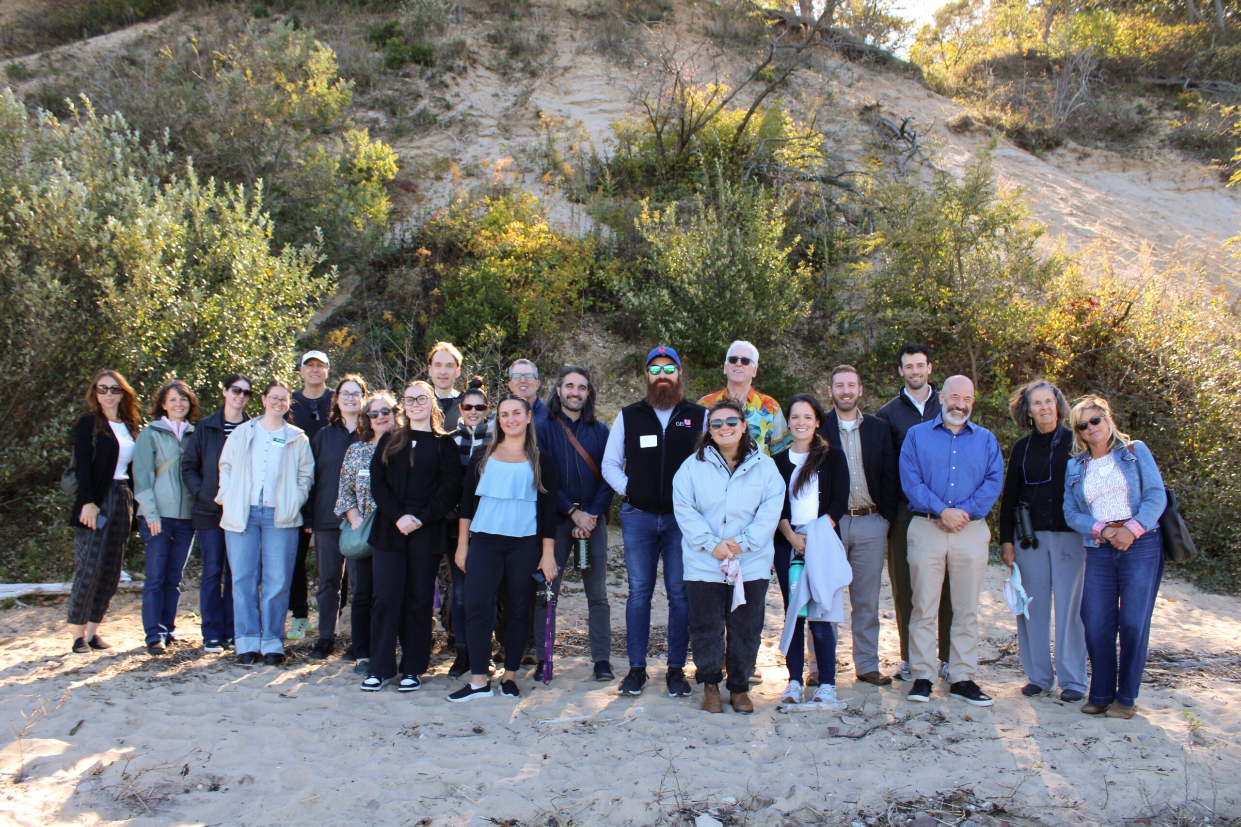
2025 Nassau Coastal Resilience Forum field trip to Sands Point Preserve. Credit: Sumayyah Uddin / NYSG
On October 9, 2025 state and local decision makers, municipal staff, and other interested parties working to address flooding, shoreline erosion and other coastal issues gathered at the Sands Point Preserve Conservancy in Sands Point, NY for the 3rd Annual Nassau County Coastal Resilience Forum. The Forum provided a chance to share information on best practices, discuss challenges, identify opportunities to increase resilience, and enhance coordination across communities. Forum attendees heard updates on State resilience initiatives from agencies like the NYS Department of Environmental Conservation and NYS Division of Homeland Security and Emergency Services, as well as presentations on new resilience tools and resources from Seatuck Environmental Association, the U.S. Geological Survey, New York Sea Grant, Cornell Cooperative Extension of Nassau County, and Nassau County Soil and Water Conservation District. In the afternoon, Forum attendees were given a guided tour of the recent expansions to the bluff stabilization project at the Preserve.
The event was hosted by Long Island Sound Partnership and New York Sea Grant, in partnership with the Sands Point Preserve Conservancy and Nassau and Suffolk County Soil and Water Conservation Districts.

SRC Training
Nassau County Coastal Resilience Forum & Field Trip – 2025
2025 Nassau Coastal Resilience Forum field trip to Sands Point Preserve. Credit: Sumayyah Uddin / NYSG
On October 9, 2025 state and local decision makers, municipal staff, and other interested parties working to address flooding, shoreline erosion and other coastal issues gathered at the Sands Point Preserve Conservancy in Sands Point, NY for the 3rd Annual Nassau County Coastal Resilience Forum. The Forum provided a chance to share information on best practices, discuss challenges, identify opportunities to increase resilience, and enhance coordination across communities. Forum attendees heard updates on State resilience initiatives from agencies like the NYS Department of Environmental Conservation and NYS Division of Homeland Security and Emergency Services, as well as presentations on new resilience tools and resources from Seatuck Environmental Association, the U.S. Geological Survey, New York Sea Grant, Cornell Cooperative Extension of Nassau County, and Nassau County Soil and Water Conservation District. In the afternoon, Forum attendees were given a guided tour of the recent expansions to the bluff stabilization project at the Preserve.
The event was hosted by Long Island Sound Partnership and New York Sea Grant, in partnership with the Sands Point Preserve Conservancy and Nassau and Suffolk County Soil and Water Conservation Districts.
Training
Long Island Sound Community Impact Fund Trainings
The Long Island Sound Community Impact Fund (LISCIF) is a partnership between Restore America’s Estuaries, the U.S. Environmental Protection Agency, and the Long Island Sound Study (LISS). The purpose of LISCIF is to build capacity for organizations located in communities affected by disproportionate environmental and human health risks. The purpose of the LISCIF is to provide technical and financial assistance to communities and improve the quality and accessibility of the Long Island Sound. The Long Island Sound Community Impact Fund seeks to increase organizational capacity through training that supports day-to-day operations, project implementation, and future funding opportunities.