
Resilience Steps
Find support and resources tailored to your project needs. Select your Planning Phase, Location, and/or Topic of interest to access a filtered selection of our curated resources and tools.

Learn
Learn about the environmental threats and climate risks in your community

Plan
Identify strategies to help mitigate risks and develop ways to adapt to a changing climate

Implement
Find funding and guidance to help put your plans into action

Sustain
Monitor, maintain, and adaptively-manage your project to sustain success
Filters
Select one or more of the filters below to find relevant tools and resources for your needs
Need help deciding where to start?
Learn how to identify, prioritize, and implement high-impact projects

Resource
Long Island Watershed Action Agenda
The Long Island Watershed Action Agenda is a clear-cut blueprint for water quality improvements, aquatic habitat conservation, groundwater protection, and the public engagement necessary to ensure success for the surface, coastal, and ground waters of Nassau and Suffolk counties. The Long Island Watershed Action Agenda is an evolution of the success of the Long Island Nitrogen Action Plan (LINAP) and will expand the scope of its work beyond nitrogen reduction.
Incentive Program
Suffolk County Septic Improvement Program
Resources and information on Suffolk County’s Reclaim Our Water Initiatives and Septic Improvement Program. Through the Septic Improvement Program homeowners can access grants from New York State and Suffolk County to replace their cesspool or septic system with a nitrogen removal septic system and leaching structure.
Website
Sustainable CT
Sustainable CT provides a wide-ranging menu of resilience best practices, opportunities for grant funding, and a voluntary certification program that recognizes thriving and resilient CT communities. Municipalities choose Sustainable CT actions, implement them, and earn points toward certification.
Plan
Superstorm Sandy Review Task Force Report to the Legislature: Looking to the Past to Prepare for the Future
The Superstorm Sandy Review Task Force conducted an in-depth review of the preparation for and response to Superstorm Sandy in Suffolk County by government agencies, first responders, nonprofits and private sector entities to determine which measures were effective and what actions must be taken in the future to increase resiliency and improve response to extreme weather events.
Plan
Suffolk County Subwatersheds Wastewater Plan: A Roadmap to Reclaim Our Water
The Suffolk County Subwatersheds Wastewater Plan serves as a county-wide roadmap for how to address nitrogen pollution through wastewater upgrades and other nitrogen pollution mitigation strategies. It was developed in collaboration with numerous project partners, stakeholders, and technical experts, and is the product of rigorous, science-based evaluations.
Incentive Program
NYSERDA Clean Energy Communities
The New York State Energy Research and Development Authority (NYSERDA) Clean Energy Communities (CEC) program helps local governments to implement clean energy actions, save energy costs, create jobs, and improve the environment. In addition to providing tools, resources, funding opportunities and technical assistance, the program recognizes and rewards leadership for the completion of clean energy projects and guides a path toward the Clean Energy Communities designation. Find your local CEC Coordinator to start!
Incentive Program
NYS Climate Smart Communities
The Climate Smart Communities (CSC) is a New York State program that helps local governments take action to reduce greenhouse gas emissions and adapt to a changing climate. The program offers grants, rebates for electric vehicles, and free technical assistance. Registered communities have made a commitment to act by passing the CSC pledge. Certified communities are the foremost leaders in the state; they have gone beyond the CSC pledge by completing and documenting a suite of actions that mitigate and adapt to climate change at the local level. Find your local CSC Coordinator to start!
Resource
Level of Effort:
UConn Extension Fact Sheet
Reducing Flood Risk in our Communities Fact Sheet
Severe rain events and flooding in our municipalities and communities is becoming more common. Flood risk reduction involves adapting infrastructure and land use to increasing flood frequency and intensity along with mitigating human impacts. While strategies must be place specific, this fact sheet provides starting point guidance on how different stakeholders in Connecticut’s land and infrastructure can contribute to reducing floods.
Resource
Level of Effort:
NYSDEC Living Shoreline Map
Check out our interactive map to learn about living shoreline projects located in the marine district of New York.
More information about living shorelines and their benefits can be found on the NYSDEC Living Shorelines webpage.
Resource
Level of Effort:
NYSDEC Living Shoreline Map
Check out our interactive map to learn about living shoreline projects located in the marine district of New York.
More information about living shorelines and their benefits can be found on the NYSDEC Living Shorelines webpage.
Mapper
Level of Effort:
NYC Stormwater Flood Maps
The NYC Stormwater Flood Maps show areas in New York City that are at risk of flooding during heavy rain. The tool provides interactive maps that let users explore neighborhood-level flood risk and understand how stormwater might affect streets, homes, and critical infrastructure. It helps residents, planners, and local organizations identify vulnerable areas and make decisions about preparedness, emergency planning, and long-term resilience.
These maps also bring together important environmental and social data, making it easier to compare neighborhoods, see patterns, and understand which communities may face the greatest challenges during extreme weather.
Resource
Level of Effort:
Adapting to Flood and Erosion Risk
A start guide for addressing flooding and erosion in coastal communities. Learn about the steps communities can take to adapt along with different adaptation strategies.
Resource
Level of Effort:
Adapting to Flood and Erosion Risk
A start guide for addressing flooding and erosion in coastal communities. Learn about the steps communities can take to adapt along with different adaptation strategies.
Website
Level of Effort:
The Atlas of Inspiration
The Atlas of Inspiration is a national database that highlights real projects helping communities adapt to extreme weather, flooding, heat, and sea-level rise. It showcases innovative infrastructure, planning strategies, and funding approaches that can be adapted or scaled by other communities. The Atlas is designed to celebrate successful ideas and give decision-makers examples they can use when seeking state or federal funding.
The Atlas is fully searchable, allowing users to browse projects by type, climate hazard, or location. It builds on Rebuild by Design’s earlier work including the Atlas of Disaster and the Atlas of Accountability by showing not only the risks communities face, but the solutions that are already making a difference.
Rebuild by Design also invites communities to share their own climate resilience projects for inclusion in the Atlas. Submissions help expand the collection and highlight new approaches being used across the country.
Report
Level of Effort:
Severe Weather Mitigation & Resiliency Advisory Council – Final Report 2025
Connecticut’s Severe Weather Mitigation and Resiliency Advisory Council was created to help the state better prepare for the growing risks of hurricanes, flooding, and other severe weather events. According to the Council and the CT Insurance Department, many Connecticut homes especially older buildings or houses in coastal and urban areas are highly vulnerable to wind and flood damage. The Council’s final report explains that severe weather is becoming more expensive for families, and many residents lack the insurance or financial resources to recover after storms. To address this, the Council recommends strengthening partnerships with programs like Energize CT, Habitat for Humanity, and the CT Green Bank, and promoting upgrades such as IBHS Fortified™ roofs, which can reduce damage from high winds. They also emphasize the need for public education about flood risk, insurance awareness, and preparedness, along with long-term actions like statewide grant programs, tax credits, and expanded training for contractors and evaluators. Together, these efforts aim to help Connecticut residents protect their homes, reduce storm damage, and build a safer, more resilient future.
You can view the complete Final Report (2025) in PDF format
Guidance Tool
Level of Effort:
Funding and Financing Coastal Resilience (Recorded Webinars)
The “Funding and Financing Coastal Resilience” webinar series from the NOAA Office for Coastal Management offers a comprehensive foundation for understanding how coastal resilience projects are funded and financed. These 30- to 45-minute recorded sessions break down complex approaches into accessible lessons, featuring experts who share real world examples, emerging strategies like environmental impact bonds and tax-increment financing, and ways to overcome common obstacles to funding such work. As a resource, the series is ideal if you’re looking to generate ideas, explore different financing pathways, and build your capacity to access and manage funding for nature-based or infrastructure-driven resilience efforts.
Report
Level of Effort:
Building a Resilient Trail
This report provides on guidance on ways to adapt the Shoreline Greenway Trail to the increasing frequencies of heavy rain, wildfires, hurricanes, flood events, and storm surges. The report defines what we mean by resilience for a trail in coastal Connecticut, identifies climate impacts facing the trail now, and in the years to come, shares design suggestions that could build resiliency on existing and new sections, and explores how the trail itself can be essential to wider community resiliency.
Website
Level of Effort:
GSI Impact Hub
The GSI Impact Hub is an interactive platform that provides tools, research, and data to help communities plan and evaluate green stormwater infrastructure (GSI) projects. GSI uses natural systems like plants, soil, and stone to manage stormwater on-site reducing flooding, improving water quality, and creating healthier, more resilient neighborhoods. The Hub includes a benefits calculator, educational resources, and guidance to support city planners, advocates, and policymakers in designing projects that maximize environmental, social, and economic benefits.
Explore the GSI Impact Calculator, Detailed Resource Library, and Project Background to better understand how GSI can reduce flooding, improve water quality, and build climate-resilient neighborhoods.
Resource
Level of Effort:
Culverts and Climate Resilience Fact Sheet
This fact sheet produced by the Connecticut Institute for Resilience and Climate Adaptation (CIRCA) reviews how culverts are defined in Connecticut, explains their connection to climate resilience, provides examples of how Connecticut towns are addressing needs for upgraded culverts, and highlights related resources.
Resource
Level of Effort:
Green Stormwater Infrastructure Workbook
This workbook made by Groundwork Bridgeport provides a thorough but accessible introduction to green stormwater infrastructure. The workbook explains the issues that green infrastructure can help solve, introduces several green infrastructure methods, and then provides definitions, explains why each is uses, and details how to build them.
Guidance Tool
Level of Effort:
Federal Flood Mitigation Funding Program Cheat Sheet
This resource outlines six different federal mitigation funding programs. It provides an overview of available options and links to learn more information and apply.
Guidance Tool
Level of Effort:
Federal Flood Mitigation Funding Program Cheat Sheet
This resource outlines six different federal mitigation funding programs. It provides an overview of available options and links to learn more information and apply.
Plan
Level of Effort:
Suffolk County Hazard Mitigation Plan
Suffolk County and the local governments within Suffolk County developed a FEMA approved Hazard Mitigation Plan, which documents risks from natural hazards and strategies to mitigate hazards.
Plan
Level of Effort:
Suffolk County Hazard Mitigation Plan
Suffolk County and the local governments within Suffolk County developed a FEMA approved Hazard Mitigation Plan, which documents risks from natural hazards and strategies to mitigate hazards.
Story Map
Level of Effort:
Westchester County Hazard Mitigation Plan Story Map
This Story Map was developed to provide an overview of the Westchester County Multi-Jurisdictional Hazard Mitigation Plan (HMP) to facilitate county-wide access to the plan. The Westchester County HMP was developed to provide a roadmap to resilience by identifying hazards affecting the county and its communities.
Guidance Tool
Level of Effort:
CT DEEP Coastal Property Owner’s Guide
Guidance for coastal property owners, buyers, contractors, or real estate professionals to understand if a shoreline structure, construction, or repair requires a permit.
Guidance Tool
Level of Effort:
CT DEEP Coastal Property Owner’s Guide
Guidance for coastal property owners, buyers, contractors, or real estate professionals to understand if a shoreline structure, construction, or repair requires a permit.
Website
Level of Effort:
NOAA State Climate Summaries
The 2022 State Climate Summaries provide new information on assessment topics directly related to NOAA’s mission, specifically historical climate variations and trends, future climate model projections of climate conditions during the 21st century, and past and future conditions of sea level and coastal flooding. Select your state to find state-level information for observed changes in climate, including both long-term trends and extreme weather events.
Story Map
Level of Effort:
NY Sea Grant Long Island Dynamic Shorelines
This story map examines the coastal processes and hazards of Long Island and provides options for sustainable and resilient shoreline management. Information is useful for coastal managers, planners and coastal property owners.
Story Map
Level of Effort:
NY Sea Grant Long Island Dynamic Shorelines
This story map examines the coastal processes and hazards of Long Island and provides options for sustainable and resilient shoreline management. Information is useful for coastal managers, planners and coastal property owners.
Mapper
Level of Effort:
Long Island Sound Crossing Prioritization Tool
The Long Island Sound Crossing Prioritization Tool can be used to prioritize road-stream crossings (culverts and bridges) for ecological, infrastructure, and community resilience benefits in Westchester, Nassau and Suffolk County, NY. The tool helps communities plan improvements that restore habitat for diadromous fishes, strengthen infrastructure, and keep communities connected.
Developed by Save the Sound in partnership with Seatuck Environmental Association and The Nature Conservancy, the Long Island Sound Crossing Prioritization Tool was built by CivicMapper and is hosted on ArcGIS Online. It is intended to be a resource for municipalities, especially parts of municipal government that make infrastructure or environmental decisions for their communities, by making it easier to apply for grant funding. The tool is a useful resource for agency partners and fellow environmental organizations working to accelerate river restoration and protect communities from a changing climate.
Mapper
Level of Effort:
USGS Compound Flood Hazard Web Map
The USGS Long Island Sound Partnership Compound Flood Hazard Web Map Application is an interactive tool developed by the U.S. Geological Survey’s New York Water Science Center that helps users explore the combined impacts of multiple flooding drivers across the New York and Connecticut coastal regions. Drivers of compound flooding included in the assessment were precipitation, coastal (storm surge, tidal), and groundwater emergence, which when combined can lead to more severe and widespread inundation than from any single cause alone.
The map visually displays hazard rankings and spatial patterns of flood drivers so that planners, emergency managers, researchers, and the public can better understand where these flood hazards are most likely to coincide, thus supporting local decision making for flood mitigation, coastal planning, and resilience strategies. The application is based on USGS models and ongoing research into regional flood processes.
Mapper
Level of Effort:
Coastal Barrier Resources System Mapper
Signed into law on November 25, 2024, the bipartisan BEACH Act (BEACH Act; Pub. L. 118-117) reauthorizes the Coastal Barrier Resources Act (CBRA) and updates maps for 454 coastal units across 13 U.S. states, including Connecticut. The revised Coastal Barrier Resources System (CBRS) maps are now effective and available through the CBRS Mapper
The BEACH Act expands eligibility for federal flood insurance and financial assistance in areas removed from the CBRS, while limiting new federal funding in areas added to the system. It also introduces new requirements for CBRA disclosures during real estate transactions, guidance for emergency coastal projects, and research initiatives on coastal barrier ecosystem dynamics.
Agencies involved:
U.S. Fish and Wildlife Service (FWS), Department of Housing and Urban Development, U.S. Army Corps of Engineers, and U.S. Geological Survey.
Guidance Tool
Level of Effort:
CT DEEP Grants Database
CT DEEP recently released a new tool allowing users to search for DEEP financial assistance programs based on a variety of parameters such as eligibility requirements, grant cycle status, project types, and more. This resource and offers “one-stop shopping” for many DEEP funding opportunities.
Data
Level of Effort:
NYC Hazard Mitigation Plan
This website contains New York City’s Federal Emergency Management Agency–mandated Hazard Mitigation Plan, which identifies natural hazard risks and vulnerabilities that are common to New York City (NYC) and long-term strategies for reducing them. It also features a Mitigation Actions Database and Map that tracks and records actions that are taken to mitigate risk from the hazards profiled in the Hazard Mitigation Plan.
Data
Level of Effort:
NYSDEC Division of Water Grants Data Portal
This portal contains the comprehensive dataset of awarded projects for the Water Quality Improvement Project Program (WQIP) and the Non-Agricultural Nonpoint Source Planning and MS4 Mapping Grant (NPG). Data is displayed simultaneously on a map and data table and can be filtered by Grant Program, Applicant, County, Project Type, and Funding Source.
Report
Level of Effort:
Averting Crisis -Zoning to Create Resilient Homes for All
This study by the Regional Plan Association assessed how flooding will threaten housing in Long Island, NYC, and Westchester County in the coming decades. It found that by 2040 as many as 1.6 million people could live in areas exposed to flooding and as many as 82,000 housing units could be lost, exacerbating housing shortages. The report includes recommendations for an integrated approach to land use planning and policy initiatives to create resilient communities.
Mapper
Level of Effort:
Connecticut Housing Data Hub
The Connecticut Housing Data Hub provides users the ability to explore several categories of state- and town-wide housing data over time. Available data on the dashboard includes permitting, housing stock, rent burden, and housing programs.
Mapper
Level of Effort:
Connecticut Housing Data Hub
The Connecticut Housing Data Hub provides users the ability to explore several categories of state- and town-wide housing data over time. Available data on the dashboard includes permitting, housing stock, rent burden, and housing programs.
Guidance Tool
Level of Effort:
FEMA National Resilience Guidance: A Collaborative Approach to Building Resilience
FEMA’s National Resilience Guidance document is intended to help all individuals, communities, and organizations understand our nation’s vision for resilience, the key principles that must be applied to strengthen resilience, and the players and systems that contribute to resilience. It also outlines how to strengthen resilience by organizing and engaging people, incorporating resilience concepts into planning efforts, creating change through policies, prioritizing projects and programs, financing resilience efforts, and measuring and evaluating resilience. Finally, the NRG includes a Resilience Maturity Model that illustrates stages in the evolution of a community’s approach to resilience.
Report
Level of Effort:
The Fifth National Climate Assessment
The Fifth National Climate Assessment is the US Government’s preeminent report on climate change impacts, risks, and responses. It is a congressionally mandated interagency effort that provides the scientific foundation to support informed decision-making across the United States.
Guidance Tool
Level of Effort:
A Guide to Permitting Shoreline Modification Projects in New York’s Tidal Waters
The permitting process for shoreline modification projects is complex and it can be daunting to know where to begin. Check out New York Sea Grant’s NEW Guide to Permitting Shoreline Modification Projects in New York’s Tidal Waters for an overview of the process informed by federal, state, and local perspectives. It is intended for permit applicants using the New York State Joint Application for shoreline construction or modification, ranging from major to minor projects such as construction of floating docks, installing natural and nature-based features, bulkhead repair, development near a wetland, dredging, and invasive species removal.
Guidance Tool
Level of Effort:
Federal Highway Administration (FHWA’s) Vulnerability Assessment and Adaptation Framework
The Federal Highway Administration (FHWA’s) Vulnerability Assessment and Adaptation Framework, 3rd Edition, is a guide and collection of resources for use in analyzing the impacts of climate change and extreme weather on transportation infrastructure. Its purpose is to identify key considerations, questions, and resources that can be used to design and implement a climate change vulnerability assessment. The processes, lessons learned, and resources outlined in the framework are geared toward state departments of transportation (DOTs), metropolitan planning organizations (MPOs), and other agencies involved in planning, building, or maintaining the transportation system. It includes suggestions and examples applicable to a wide range of applications, from small qualitative studies to large, detailed, data-intensive analyses. The resources included in the framework will be added to and updated over time.
Mapper
Level of Effort:
CT ECO Lower Long Island Sound Watershed Land Cover Viewer
The Long Island Sound Watershed Land Cover Viewer contains all dates of land cover as well as Change To, Change From, Riparian Area Land Cover, and Impervious Surface Estimate layers. It also has many layers where HUC 12 watersheds are colored based on a single land cover.
Mapper
Level of Effort:
CT ECO Advanced Viewer
Connecticut Environmental Conditions Online (CT ECO) is the collaborative work of the Connecticut Department of Energy and Environmental Protection (DEEP) and the University of Connecticut Center for Land Use Education and Research (CLEAR) to share environmental and natural resource information with the general public. CT ECO’s mission is to encourage, support, and promote informed land use and development decisions in Connecticut by providing local, state and federal agencies, and the general public with convenient access to the most up-to-date and complete natural resource information available statewide.
CT ECO includes a variety of online maps and tools for viewing Connecticut’s environmental and natural resources as well as high resolution aerial imagery, elevation data, and land cover. The Advanced Map Viewer provides flexibility to turn on and off layers of the map.
Mapper
Level of Effort:
Road-Stream and Tidal Crossing Prioritization Tool – Suffolk County, Long Island
Developed by The Nature Conservancy, this tool identifies priority road-stream and tidal crossings in Suffolk County for replacement or upgrades. Prioritization is based on social and ecological criteria. Additionally, it includes data on current and future projected flooding and marsh extent under various sea level rise scenarios. The tool is meant to be a screening tool for planning efforts.
Mapper
Level of Effort:
Long Island Water Reuse Road Map and Action Plan
Seatuck and the Greentree Foundation, in association with Cameron Engineering, initiated the Long Island Water Reuse Roadmap and Action Plan to catalyze the implementation of water reuse on Long Island and ensure that the strategy plays a larger and more meaningful role in safeguarding the region’s drinking water and surface water resources.
Mapper
Level of Effort:
Connecticut Environmental Conditions Online (CTEco) — CTDEEP & CLEAR
Connecticut-specific site with maps, data, and visualization tools. Contains: Blue Plan, MS4 Viewer, CT Parcel Viewer, Sea Level Rise Effects on Roads & Marshes, CT DEEP Fish Community Data – Inland Waters, CT Aquaculture Mapping Atlas, CT Coastal Hazards Viewer, Carbon Stock & Land Cover Viewer
Website
Level of Effort:
Connecticut Coastal Permitting
Contains guidance documents and information on coastal permitting from the State of Connecticut.
Website
Level of Effort:
Connecticut Coastal Permitting
Contains guidance documents and information on coastal permitting from the State of Connecticut.
Mapper
Level of Effort:
FEMA Region 2 Community Profiles
These community profiles are intended to be used by municipal officials and planners working to make their communities more economically, environmentally, and socially resilient. Includes datasets related to FEMA disaster and non-disaster funding, flood insurance claims, social vulnerability, and other community stats.
Mapper
Level of Effort:
FEMA Resilience Analysis and Planning Tool (RAPT)
RAPT provides access to important data and analysis tools to support your community before, during and after a disaster.
Mapper
Level of Effort:
FEMA Resilience Analysis and Planning Tool (RAPT)
RAPT provides access to important data and analysis tools to support your community before, during and after a disaster.
Guidance Tool
Level of Effort:
Georgetown Climate Center Managed Retreat Toolkit
This toolkit features legal and policy tools, best and emerging practices, and case studies to support learning and decision making around managed retreat and climate adaptation. It is meant to be used by state, territorial, and local policymakers in U.S. coastal jurisdictions
Plan
Level of Effort:
Nassau County Hazard Mitigation Plan
The Nassau County Hazard Mitigation Plan was developed through a year-long interactive planning process in close coordination with stakeholders. The process included identifying the hazards of concern within the County, assessing those hazards, estimating risk, and developing a strategy to mitigate risk to these hazards throughout the County.
Mapper
Level of Effort:
Neighborhoods At Risk
Neighborhoods at Risk is an easy-to-use website with interactive maps, charts, and resources to help communities identify neighborhoods that may be more impacted by climate change. It shows where people may experience unequal impacts from flooding and extreme heat.
Mapper
Level of Effort:
NOAA Digital Coast – Coastal Flood Exposure Mapper
Use this mapper to visualize people, infrastructure, and natural resources exposed to coastal flood hazards. You can save and share the online maps to communicate with stakeholders. Tip: watch the short video about the tool before getting started!
Mapper
Level of Effort:
NOAA Digital Coast – Sea Level Calculator
This tool produces location-specific scenarios for sea level and flooding, as well as information about present-day and past conditions. Local governments and other practitioners can use the information to make informed decisions about strategic adaptation investments. The site incorporates data, maps, and visualizations and produces automated, location-specific reports.
Mapper
Level of Effort:
NOAA Sea Level Rise Viewer
Use this web mapping tool to visualize community-level impacts from coastal flooding or sea level rise (up to 10 feet above average high tides). Photo simulations of how future flooding might impact local landmarks are also provided, as well as data related to water depth, connectivity, flood frequency, socio-economic vulnerability, wetland loss and migration, and mapping confidence.
Mapper
Level of Effort:
Northeast Ocean Data Portal
User-friendly access to expert-reviewed interactive maps on key topics such as marine life and habitat, marine-based industry, use and resources in the northeastern United States. The Data Explorer allows the user to define and view any combination of data hosted on the Portal on one map.
Mapper
Level of Effort:
The Long Island Sound and Watershed Metadata Map Application
The Long Island Sound watershed is home to nearly 9 million people in parts of Connecticut, Massachusetts, New Hampshire, New York, Rhode Island, Vermont, and Canada. Government agencies, nonprofits, and Tribal Nations have overseen numerous projects to monitor and protect the water resources of this watershed and the sound. Although there is an abundance of data, there is no easy way to search them or a central place to manage this information. To help, the U.S. Geological Survey, the U.S. Environmental Protection Agency, and the Long Island Sound Study have created an interactive map to help users find and understand data about the water resources of the Long Island Sound and its watershed.
This mapping tool does not host data or maintain data repositories. Instead, it compiles and presents metadata from publicly accessible databases managed by State and other organizations.
Refer to this fact sheet for details about the application and its data sources: The Long Island Sound and Watershed Metadata map application
Mapper
Level of Effort:
CTDOT Drainage Network Interactive Map
This interactive map published by the CTDOT in March 2025 allows users to view data layers that make up the state-owned and maintained drainage network across Connecticut. Culvert locations are included, as well as their water source, material components, type of conveyance, diameter, length, last inspection date, and maintenance information. Note that an ArcGIS login is required to access this resource.
Mapper
Level of Effort:
Connecticut Sea Level Rise Effects on Roads & Marshes
To better understand how Connecticut’s coastal area marshes and roads may respond to sea level rise (SLR), Sea Level Affecting Marshes Model (SLAMM) was applied to Connecticut’s shoreline by Warren Pinnacle Consulting, Inc. This viewer displays the model’s results for Connecticut’s 21 largest marshes and all coastal area roads. For marshes, SLAMM was run two hundred times using alternative model inputs for key model parameters, including various SLR scenarios, to produce probability based results of likely future marsh conditions. For roads, the model uses a single SLR scenario of about 4.2 feet by 2100 from the base year of 2002. The Sea Level Rise Effects on Roads and Marshes projects is a project between CT DEEP and UConn CLEAR.
Guidance Tool
Level of Effort:
NYS Stormwater Design Manual
The New York State Stormwater Management Design Manual provides designers with a general overview on how to size, design, select, and locate stormwater management practices at a development site to comply with State stormwater performance standards.
Guidance Tool
Level of Effort:
CT MS4 Guide
Developed by the NEMO program at the UConn Center for Land Use Education and Research, this website provides guidance and tools to help Connecticut municipalities and institutions comply with the MS4 general permit.
Guidance Tool
Level of Effort:
CT MS4 Guide
Developed by the NEMO program at the UConn Center for Land Use Education and Research, this website provides guidance and tools to help Connecticut municipalities and institutions comply with the MS4 general permit.
Guidance Tool
Level of Effort:
NOAA Digital Coast – Ecosystem Services
Healthy ecosystems provide a wide range of benefits, from recreational opportunities to storm surge protection. These benefits are often referred to as ecosystem services. Understanding how changes to the ecosystem may affect these benefits should play a role in the community’s decision making process. This page provides a guide to learning more and key NOAA Digital Coast resources useful for this task.
Mapper
Level of Effort:
NOAA Digital Coast – Sea Level Affecting Marshes Model (SLAMM)
The Sea Level Affecting Marshes Model, or SLAMM, uses digital data and other information to simulate potential impacts of long-term sea level rise on wetlands and shorelines. Additional data related to dike locations or other protected areas, accretion rates, erosion rates, and other factors can be included within the model as optional factors. Requires ArcGIS for viewing outputs in a mapping environment and software, such as Microsoft Excel and Word, to view the text and tabular output.
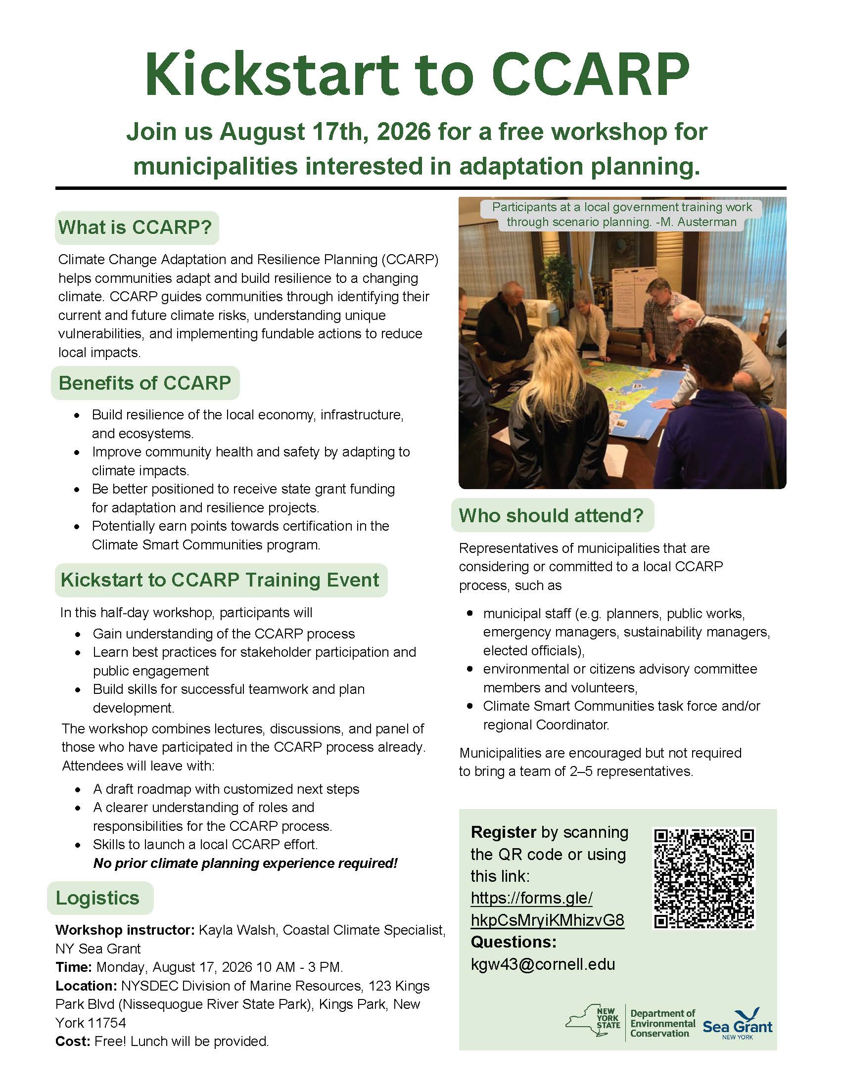
Training
Kickstart to CCARP Training for Long Island Municipalities
Join us August 17 at the NYSDEC Division of Marine Resources for a FREE training for municipalities starting out or working towards adapting to climate impacts! Learn how a Climate Change Adaptation and Resilience Plan (CCARP) can help your community build resilience to a changing climate and extreme weather. Lunch will be provided.
Through this training, attendees will:
- Gain an Understanding of the CCARP process
- Learn best practices for stakeholder participation and public engagement
- Build skills for successful teamwork and plan development
Municipalities are encouraged (but not required) to bring a team of 2-5 representatives, including municipal staff, environmental or citizens advisory committee members, and/or Climate Smart Communities task force members.
SRC Training
USGS Compound Flood Hazard Assessment Mapper Webinar
This virtual webinar featured the U.S. Geological Survey’s (USGS) new Compound Flood Hazard Assessment Mapper. Municipal staff, state agencies, and other partners joined to learn how USGS developed this new tool and how they could utilize it in planning and decision-making.
This webinar was hosted by New York Sea Grant, Connecticut Sea Grant, and the U.S. Geological Survey, with funding from Long Island Sound Partnership.
For questions or more information, email Kathleen Fallon.
A recording of the webinar along with webinar slides and a Q&A and references document is available below.
SRC Training
Suffolk County Coastal Resilience Forum & Field Trip – 2025
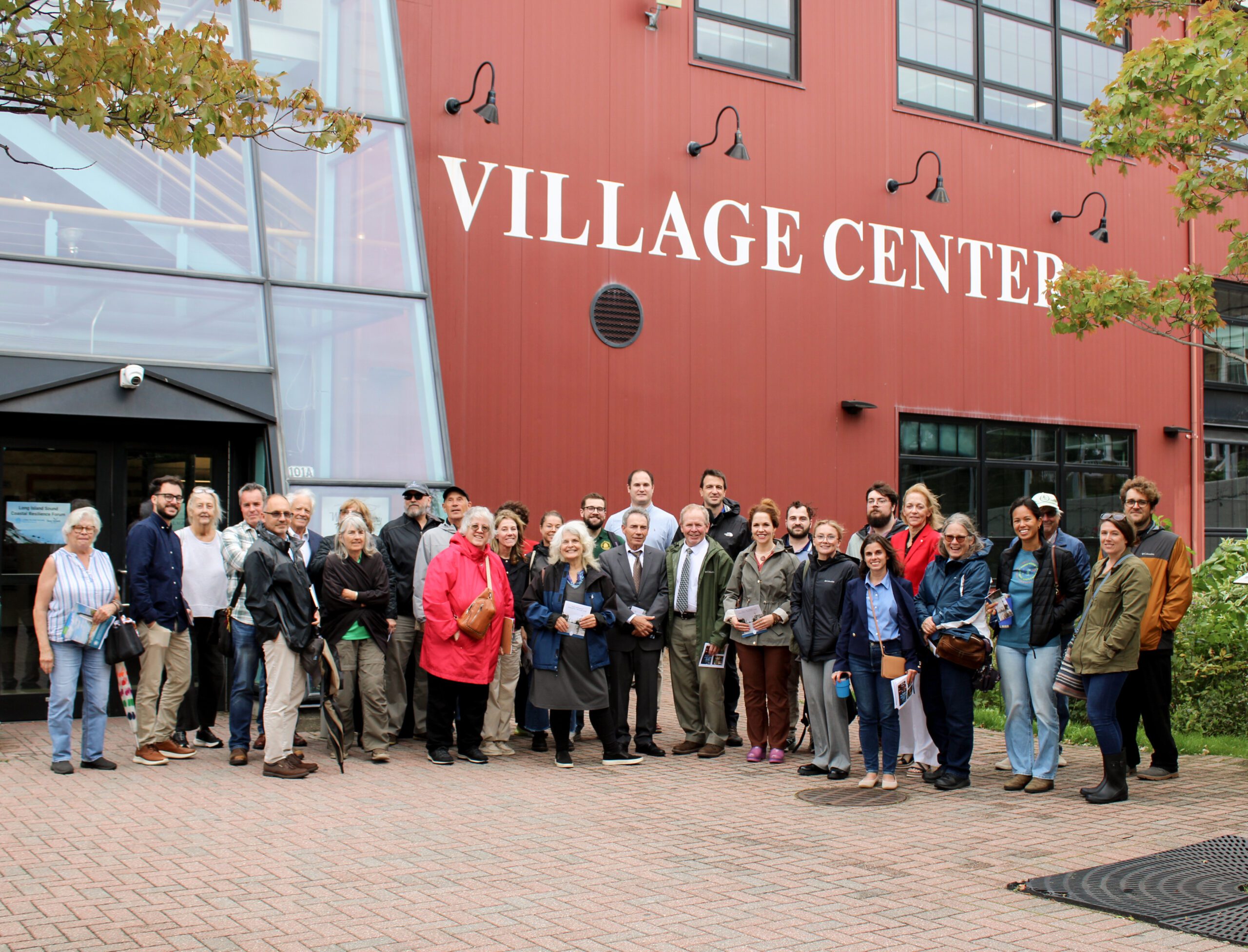
On October 8, 2025 state and local decision makers, municipal staff, and other interested parties working to address flooding, shoreline erosion and other coastal issues gathered at the Port Jefferson Village Center in Port Jefferson, NY for the 3rd Annual Suffolk County Coastal Resilience Forum. The Forum provided a chance to share information on best practices, discuss challenges, identify opportunities to increase resilience, and enhance coordination across communities. Forum attendees heard updates on State resilience initiatives from the NYS Department of Environmental Conservation and NYS Division of Homeland Security and Emergency Services, as well as presentations on new resilience tools and resources from Seatuck Environmental Association, the U.S. Geological Survey, New York Sea Grant, and Suffolk County Soil and Water Conservation District. In the afternoon, Village of Port Jefferson Mayor, Lauren Sheprow, presented on the Village’s resilience issues and initiatives and then led attendees on a walking tour of the Village highlighting flooding hotspots, challenges faced by local businesses and residents, and efforts to help mitigate flooding and increase community resilience.
The event was hosted by Long Island Sound Partnership and New York Sea Grant, in partnership with the Village of Port Jefferson and Suffolk County Soil and Water Conservation District.
SRC Training
Suffolk County Coastal Resilience Forum & Field Trip – 2025
On October 8, 2025 state and local decision makers, municipal staff, and other interested parties working to address flooding, shoreline erosion and other coastal issues gathered at the Port Jefferson Village Center in Port Jefferson, NY for the 3rd Annual Suffolk County Coastal Resilience Forum. The Forum provided a chance to share information on best practices, discuss challenges, identify opportunities to increase resilience, and enhance coordination across communities. Forum attendees heard updates on State resilience initiatives from the NYS Department of Environmental Conservation and NYS Division of Homeland Security and Emergency Services, as well as presentations on new resilience tools and resources from Seatuck Environmental Association, the U.S. Geological Survey, New York Sea Grant, and Suffolk County Soil and Water Conservation District. In the afternoon, Village of Port Jefferson Mayor, Lauren Sheprow, presented on the Village’s resilience issues and initiatives and then led attendees on a walking tour of the Village highlighting flooding hotspots, challenges faced by local businesses and residents, and efforts to help mitigate flooding and increase community resilience.
The event was hosted by Long Island Sound Partnership and New York Sea Grant, in partnership with the Village of Port Jefferson and Suffolk County Soil and Water Conservation District.
SRC Training
Nassau County Coastal Resilience Forum & Field Trip – 2025
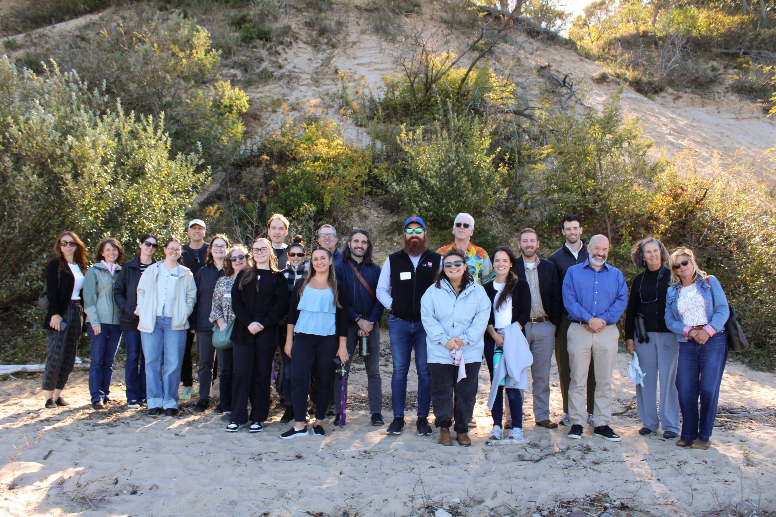
2025 Nassau Coastal Resilience Forum field trip to Sands Point Preserve. Credit: Sumayyah Uddin / NYSG
On October 9, 2025 state and local decision makers, municipal staff, and other interested parties working to address flooding, shoreline erosion and other coastal issues gathered at the Sands Point Preserve Conservancy in Sands Point, NY for the 3rd Annual Nassau County Coastal Resilience Forum. The Forum provided a chance to share information on best practices, discuss challenges, identify opportunities to increase resilience, and enhance coordination across communities. Forum attendees heard updates on State resilience initiatives from agencies like the NYS Department of Environmental Conservation and NYS Division of Homeland Security and Emergency Services, as well as presentations on new resilience tools and resources from Seatuck Environmental Association, the U.S. Geological Survey, New York Sea Grant, Cornell Cooperative Extension of Nassau County, and Nassau County Soil and Water Conservation District. In the afternoon, Forum attendees were given a guided tour of the recent expansions to the bluff stabilization project at the Preserve.
The event was hosted by Long Island Sound Partnership and New York Sea Grant, in partnership with the Sands Point Preserve Conservancy and Nassau and Suffolk County Soil and Water Conservation Districts.
SRC Training
Nassau County Coastal Resilience Forum & Field Trip – 2025
2025 Nassau Coastal Resilience Forum field trip to Sands Point Preserve. Credit: Sumayyah Uddin / NYSG
On October 9, 2025 state and local decision makers, municipal staff, and other interested parties working to address flooding, shoreline erosion and other coastal issues gathered at the Sands Point Preserve Conservancy in Sands Point, NY for the 3rd Annual Nassau County Coastal Resilience Forum. The Forum provided a chance to share information on best practices, discuss challenges, identify opportunities to increase resilience, and enhance coordination across communities. Forum attendees heard updates on State resilience initiatives from agencies like the NYS Department of Environmental Conservation and NYS Division of Homeland Security and Emergency Services, as well as presentations on new resilience tools and resources from Seatuck Environmental Association, the U.S. Geological Survey, New York Sea Grant, Cornell Cooperative Extension of Nassau County, and Nassau County Soil and Water Conservation District. In the afternoon, Forum attendees were given a guided tour of the recent expansions to the bluff stabilization project at the Preserve.
The event was hosted by Long Island Sound Partnership and New York Sea Grant, in partnership with the Sands Point Preserve Conservancy and Nassau and Suffolk County Soil and Water Conservation Districts.
SRC Training
3rd Annual SRC Workshop: Session 1 – SRC Resilience Assistance Programs
The Long Island Sound Sustainable and Resilient Communities (SRC) Team held our 2024 Annual Workshop virtually as three sessions over two days. Session topics focused on our assistance programs, new regional resilience resources and tools, and a discussion on planning for inundation and different considerations communities may face.
Session 1 – SRC Resilience Assistance Programs was held on Tuesday, December 10th from 10-11:30 AM. Participants learned about our Sustainable and Resilient Communities resilience assistance programs and heard from communities who have successfully utilized them to advance resilience project plans, build capacity, and secure competitive grant funding!
SRC Training
SRC Annual Bi-State Workshop 2023
The second annual Long Island Sound Bi-State Sustainable and Resilient Communities Workshop brought together nearly 200 people virtually on Dec. 7, 2023 to learn about a new Long Island Sound Resilience Resource Hub (launching in early 2024), hear from communities and groups around the Sound working on resilience planning, and consider pathways for updating codes and ordinances. Videos of the workshop’s six sessions are available on YouTube. They can be accessed below along with supporting documents.
SRC Training
SRC Annual Bi-State Workshop 2022
The first annual Long Island Sound Bi-State Sustainable and Resilient Communities Workshop brought together more than 260 people virtually on Dec. 1, 2022 to learn about opportunities to increase the resilience of the Sound’s communities to climate change and other environmental threats. Interactive sessions included opportunities to learn more about the SRC Extension Professionals’ needs assessment findings and recommendations, the newly released Long Island Sound Resilience Grant Writing Assistance Program, and tips for success with Long Island Sound funding opportunities. Concurrent breakout sessions highlighted the work of partners related to shoreline planning and implementation, using green infrastructure for stormwater management, sustainable climate planning for relocation, and new sustainability/resilience tools available in both New York and Connecticut. Videos of the workshop’s six sessions are available on YouTube. They can be accessed below along with supporting documents.
Case Study
Plan
East Haddam, CT
East Haddam Community Resilience Building Summary of Findings
With support from the Nature Conservancy and Sustainable CT, East Haddam organized a Community Resilience Building process and workshop, the results of which were compiled into this summary. The team engaged with community members to determine the present hazards and vulnerabilities and identify resilient solutions.
Case Study
Project
Norwalk, CT
Webster Street Parking Lot Green Infrastructure Project
In 2019, the City of Norwalk secured a LIS Future Fund grant to install green infrastructure in the Webster Street Parking to reduce the impacts of stormwater on the Norwalk River and Harbor and mitigate local flooding of surrounding businesses through the installation of four different types of infiltration and bio-retention structures:
1) Underground infiltration systems.
2) Retention basins and curb inlet planters in eight different areas.
3) Porous pavement with storage in two areas.
4) Infiltration gutters and tree filters in two other areas.
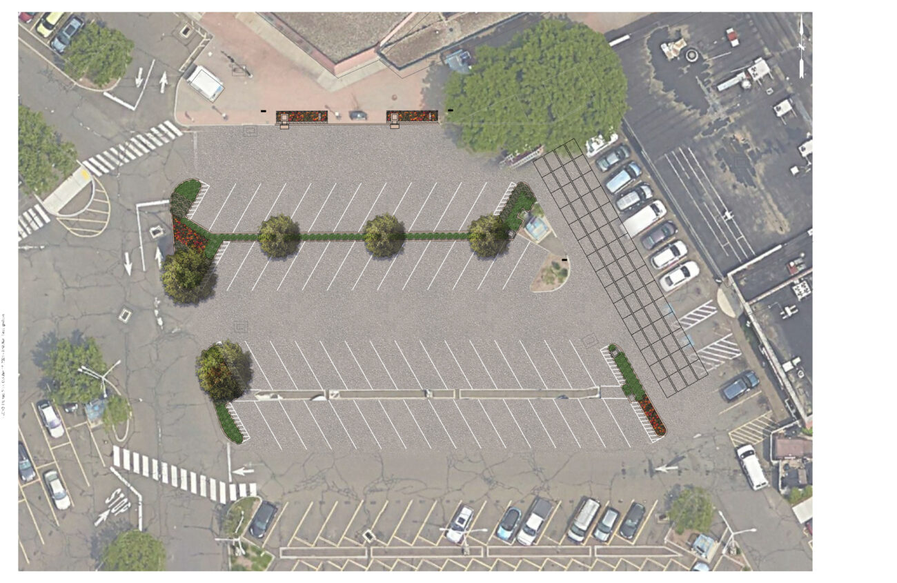

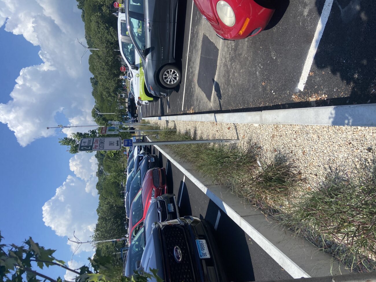


The project is estimated to remove 12 lbs. of nitrogen and preventing over 6 million gallons of stormwater from entering Norwalk Harbor annually. Since it’s installation, the site has not experienced any flooding incidents (as of 2024), indicating that it seems to be functioning well.
Bryan Lutz
Assistant Director of Parking
blutz@norwalkct.gov; 203-854-7253
Case Study
Project
Norwalk, CT
Webster Street Parking Lot Green Infrastructure Project
In 2019, the City of Norwalk secured a LIS Future Fund grant to install green infrastructure in the Webster Street Parking to reduce the impacts of stormwater on the Norwalk River and Harbor and mitigate local flooding of surrounding businesses through the installation of four different types of infiltration and bio-retention structures:
1) Underground infiltration systems.
2) Retention basins and curb inlet planters in eight different areas.
3) Porous pavement with storage in two areas.
4) Infiltration gutters and tree filters in two other areas.
Case Study
Project
Sea Cliff, NY
Scudders Pond Subwatershed Improvements
The Hempstead Harbor Protection Committee and Village of Sea Cliff completed subwatershed improvements at Scudders Pond to address stormwater drainage problems impacting the water quality of the pond and Hempstead Harbor, highlighted as a priority in the 1998 Hempstead Harbor Water Quality Improvement Plan. The improvements included dredging the pond, installing a hydrodynamic separator to intercept sediment, removing invasive Phragmites australis and replacing with native plants, realigning the stream to reduce erosion, redirecting the stormwater from residences to the bioswale, creation of a biofilter wetland area, replacement of the weir between the upper and lower ponds and weir at Shore Road.

Water quality improvements in Scudders Pond and Hempstead Harbor, views of the Pond have been restored.
Eric Swenson, Hempstead Harbor Protection Committee, hempsteadharbor@gmail.com
Case Study
Project
Sea Cliff, NY
Scudders Pond Subwatershed Improvements
The Hempstead Harbor Protection Committee and Village of Sea Cliff completed subwatershed improvements at Scudders Pond to address stormwater drainage problems impacting the water quality of the pond and Hempstead Harbor, highlighted as a priority in the 1998 Hempstead Harbor Water Quality Improvement Plan. The improvements included dredging the pond, installing a hydrodynamic separator to intercept sediment, removing invasive Phragmites australis and replacing with native plants, realigning the stream to reduce erosion, redirecting the stormwater from residences to the bioswale, creation of a biofilter wetland area, replacement of the weir between the upper and lower ponds and weir at Shore Road.
Case Study
Plan
Huntington, NY
Crab Meadow Watershed Hydrology Study and Stewardship Plan
This comprehensive study and plan, funded through the National Fish and Wildlife Foundation, Long Island Sound Futures Fund, identifies initial strategies to maintain and enhance the local watershed resources of Crab Meadow. It is meant to be a land management tool to guide the implementation of best practices. The plan was developed in consultation with many partners and stakeholders. There is now significant community buy-in to take action to protect and restore this important watershed.
Following adoption of the plan, the Town of Huntington began working with US Fish and Wildlife Service and Audubon to study and restore Crab Meadow marsh and implement recommendations from the Stewardship Plan. Audubon, in partnership with Town of Huntington and USFWS, received a 2024 Long Island Sound Futures Fund Grant ($429K) to develop design plans for marsh restoration at Crab Meadow.
Garrett Chelius gchelius@huntingtonny.gov, Victoria O’Neill victoria.oneill@audubon.org, Suzanne Paton suzanne_paton@fws.gov
 Photo by Jonah Saitz, USFWS.
Case Study
Plan
Huntington, NY
Crab Meadow Watershed Hydrology Study and Stewardship Plan
This comprehensive study and plan, funded through the National Fish and Wildlife Foundation, Long Island Sound Futures Fund, identifies initial strategies to maintain and enhance the local watershed resources of Crab Meadow. It is meant to be a land management tool to guide the implementation of best practices. The plan was developed in consultation with many partners and stakeholders. There is now significant community buy-in to take action to protect and restore this important watershed.
Following adoption of the plan, the Town of Huntington began working with US Fish and Wildlife Service and Audubon to study and restore Crab Meadow marsh and implement recommendations from the Stewardship Plan. Audubon, in partnership with Town of Huntington and USFWS, received a 2024 Long Island Sound Futures Fund Grant ($429K) to develop design plans for marsh restoration at Crab Meadow.